Cañizal elevation
Cañizal (Castille and León, Provincia de Zamora), Spain elevation is 795 meters and Cañizal elevation in feet is 2608 ft above sea level [src 1]. Cañizal is a seat of a third-order administrative division (feature code) with elevation that is 192 meters (630 ft) bigger than average city elevation in Spain.
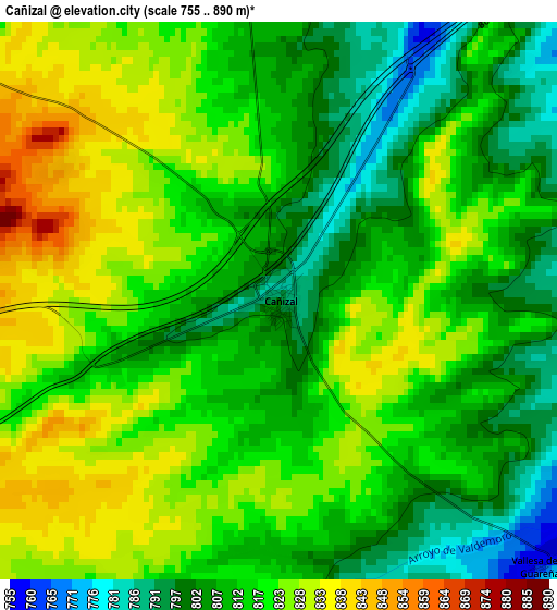
Below is the Elevation map of Cañizal, which displays elevation range with different colors. Scale of the first map is from 755 to 890 m (2477 to 2920 ft) with average elevation of 815.2 meters (=2675 ft) [note 1]
These maps also provides idea of topography and contour of this city, they are displayed at different zoom levels. More info about maps, scale and edge coordinates you can find below images.
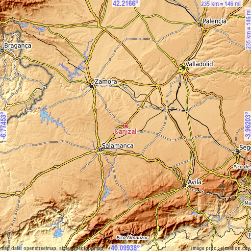
| \ | Map #1 | Topo.Map |
| Scale [m] | 755..890 m | × |
| Scale [ft] | 2477..2920 ft | × |
| Average | 815.2 m = 2675 ft | × |
| Width | 7.36 km = 4.6 mi | 235.4 km = 146.3 mi |
| Height | 7.36 km = 4.6 mi | 235.4 km = 146.3 mi |
| ↑Max Latitude | 41.199614° | 42.2166° |
| Latitude at center | 41.16654° | 41.16654° |
| ↓Min Latitude | 41.13345° | 40.09938° |
| ← Min Longitude | -5.412225° | -6.77453° |
| Longitude center | -5.36828° | -5.36828° |
| →Max Longitude | -5.324335° | -3.96203° |
Nearby cities:
Cities around Cañizal sort by population:
• Fuentesaúco elevation 804 m
12.9 km,  303°
303°
• Cantalpino 809 m
13 km,  165°
165°
• Fuentelapeña 744 m
9.5 km,  352°
352°
• Tarazona de Guareña 771 m
9.9 km,  86°
86°
• Villaescusa 828 m
9.1 km, 298°
• Vadillo de la Guareña 716 m
12.9 km,  5°
5°
• Torrecilla de la Orden 779 m
13.4 km,  64°
64°
• Espino de la Orbada 800 m
8.2 km,  215°
215°
• Parada de Rubiales 843 m
6.1 km,  250°
250°
• Aldeanueva de Figueroa 873 m
13.2 km,  261°
261°
• Vallesa de la Guareña 771 m
5 km,  134°
134°
• Castrillo de la Guareña 730 m
8 km,  26°
26°
Multilingual:
 En español:
Cañizal elevación 795 m.
 En France:
Cañizal élévation 795 m.


Sources and notes:
- [note 1] Map square and city borders are not equal. Map elevation data is calculated only from area inside that square.
- [src 1] Elevation data from geonames database provided with same terms of usage.
- [src 2] The elevation map of Cañizal is generated using elevation data from NASA's 3 arcsec (90m) resolution SRTM data.
- [src 3] Base (background) map © OpenStreetMap contributors tiles are generated by Geofabrik and OpenTopoMap.
Copyright & License:
This Cañizal Elevation Map is licensed under CC BY-SA. You may reuse any part from this page, if you give a proper credit by linking to this URL:
 More info on terms of use page.