Gallegos del Río elevation
Gallegos del Río (Castille and León, Provincia de Zamora), Spain elevation is 719 meters and Gallegos del Río elevation in feet is 2359 ft above sea level [src 1]. Gallegos del Río is a seat of a third-order administrative division (feature code) with elevation that is 116 meters (381 ft) bigger than average city elevation in Spain.
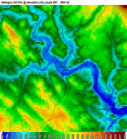
Below is the Elevation map of Gallegos del Río, which displays elevation range with different colors. Scale of the first map is from 697 to 884 m (2287 to 2900 ft) with average elevation of 766.4 meters (=2514 ft) [note 1]
These maps also provides idea of topography and contour of this city, they are displayed at different zoom levels. More info about maps, scale and edge coordinates you can find below images.
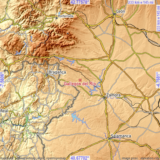
| \ | Map #1 | Topo.Map |
| Scale [m] | 697..884 m | × |
| Scale [ft] | 2287..2900 ft | × |
| Average | 766.4 m = 2514 ft | × |
| Width | 7.29 km = 4.5 mi | 233.4 km = 145 mi |
| Height | 7.29 km = 4.5 mi | 233.4 km = 145 mi |
| ↑Max Latitude | 41.767755° | 42.77578° |
| Latitude at center | 41.73497° | 41.73497° |
| ↓Min Latitude | 41.702168° | 40.67702° |
| ← Min Longitude | -6.218295° | -7.5806° |
| Longitude center | -6.17435° | -6.17435° |
| →Max Longitude | -6.130405° | -4.7681° |
Nearby cities:
Cities around Gallegos del Río sort by population:
• Alcañices elevation 802 m
14.8 km,  254°
254°
• Fonfría 805 m
11.5 km,  165°
165°
• Ríofrío de Aliste 795 m
9.2 km,  358°
358°
• Rabanales 835 m
8.5 km,  275°
275°
• San Vitero 862 m
15.2 km,  288°
288°
• Ferreruela 828 m
9.2 km,  67°
67°
• San Vicente de la Cabeza 764 m
10.2 km,  321°
321°
• Olmillos de Castro 767 m
17.1 km,  91°
91°
• Losacino 701 m
9.9 km,  127°
127°
• Samir de los Caños 792 m
7 km, 173°
• Vegalatrave 691 m
6.8 km,  124°
124°
• Losacio 752 m
11.4 km,  103°
103°
Multilingual:
 En español:
Gallegos del Río elevación 719 m.
 En France:
Gallegos del Río élévation 719 m.
 Auf Deutsch:
Gallegos del Río höhe über dem Meeresspiegel ist 719 m.

Sources and notes:
- [note 1] Map square and city borders are not equal. Map elevation data is calculated only from area inside that square.
- [src 1] Elevation data from geonames database provided with same terms of usage.
- [src 2] The elevation map of Gallegos del Río is generated using elevation data from NASA's 3 arcsec (90m) resolution SRTM data.
- [src 3] Base (background) map © OpenStreetMap contributors tiles are generated by Geofabrik and OpenTopoMap.
Copyright & License:
This Gallegos del Río Elevation Map is licensed under CC BY-SA. You may reuse any part from this page, if you give a proper credit by linking to this URL:
 More info on terms of use page.