San Vitero elevation
San Vitero (Castille and León, Provincia de Zamora), Spain elevation is 862 meters and San Vitero elevation in feet is 2828 ft above sea level [src 1]. San Vitero is a seat of a third-order administrative division (feature code) with elevation that is 259 meters (850 ft) bigger than average city elevation in Spain.
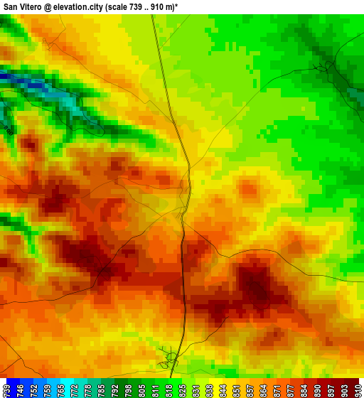
Below is the Elevation map of San Vitero, which displays elevation range with different colors. Scale of the first map is from 739 to 910 m (2425 to 2986 ft) with average elevation of 847.7 meters (=2781 ft) [note 1]
These maps also provides idea of topography and contour of this city, they are displayed at different zoom levels. More info about maps, scale and edge coordinates you can find below images.
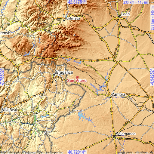
| \ | Map #1 | Topo.Map |
| Scale [m] | 739..910 m | × |
| Scale [ft] | 2425..2986 ft | × |
| Average | 847.7 m = 2781 ft | × |
| Width | 7.29 km = 4.5 mi | 233.2 km = 144.9 mi |
| Height | 7.29 km = 4.5 mi | 233.2 km = 144.9 mi |
| ↑Max Latitude | 41.810163° | 42.81751° |
| Latitude at center | 41.7774° | 41.7774° |
| ↓Min Latitude | 41.74462° | 40.72014° |
| ← Min Longitude | -6.392715° | -7.75502° |
| Longitude center | -6.34877° | -6.34877° |
| →Max Longitude | -6.304825° | -4.94252° |
Nearby cities:
Cities around San Vitero sort by population:
• Alcañices elevation 802 m
8.7 km,  178°
178°
• Ríofrío de Aliste 795 m
14.9 km,  72°
72°
• Rabanales 835 m
7.1 km,  122°
122°
• Gallegos del Río 719 m
15.2 km,  108°
108°
• San Vicente de la Cabeza 764 m
8.8 km, 68°
• Villardeciervos 856 m
19 km,  15°
15°
• Ferreras de Arriba 897 m
18.6 km,  43°
43°
• Figueruela de Arriba 854 m
12.9 km,  321°
321°
• Mahide 826 m
10.5 km,  346°
346°
• Rábano de Aliste 798 m
7.9 km,  242°
242°
• Trabazos 729 m
12.2 km,  254°
254°
• Viñas 757 m
10.2 km,  267°
267°
Multilingual:
 En español:
San Vitero elevación 862 m.
 En France:
San Vitero élévation 862 m.
 Auf Deutsch:
San Vitero höhe über dem Meeresspiegel ist 862 m.

Sources and notes:
- [note 1] Map square and city borders are not equal. Map elevation data is calculated only from area inside that square.
- [src 1] Elevation data from geonames database provided with same terms of usage.
- [src 2] The elevation map of San Vitero is generated using elevation data from NASA's 3 arcsec (90m) resolution SRTM data.
- [src 3] Base (background) map © OpenStreetMap contributors tiles are generated by Geofabrik and OpenTopoMap.
Copyright & License:
This San Vitero Elevation Map is licensed under CC BY-SA. You may reuse any part from this page, if you give a proper credit by linking to this URL:
 More info on terms of use page.