Grado elevation
Grado (Asturias, Province of Asturias), Spain elevation is 84 meters and Grado elevation in feet is 276 ft above sea level [src 1]. Grado is a populated place (feature code) with elevation that is 519 meters (1703 ft) smaller than average city elevation in Spain.
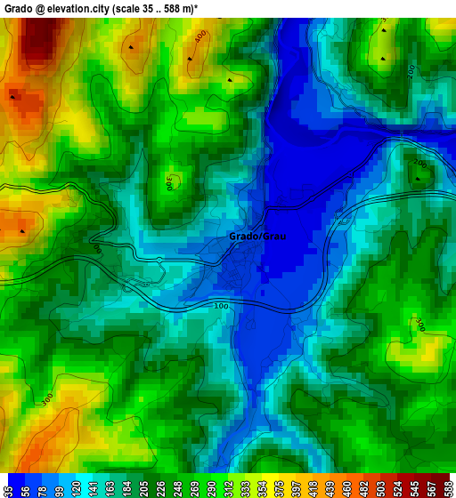
Below is the Elevation map of Grado, which displays elevation range with different colors. Scale of the first map is from 35 to 588 m (115 to 1929 ft) with average elevation of 219.6 meters (=720 ft) [note 1]
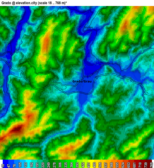
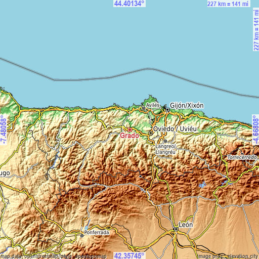
These maps also provides idea of topography and contour of this city, they are displayed at different zoom levels. More info about maps, scale and edge coordinates you can find below images.
| \ | Map #1 | Map #2 | Topo.Map |
| Scale [m] | 35..588 m | 18..768 m | × |
| Scale [ft] | 115..1929 ft | 59..2520 ft | × |
| Average | 219.6 m = 720 ft | 252 m = 827 ft | × |
| Width | 7.1 km = 4.4 mi | 14.2 km = 8.8 mi | 227.3 km = 141.2 mi |
| Height | 7.1 km = 4.4 mi | 14.2 km = 8.8 mi | 227.2 km = 141.2 mi |
| ↑Max Latitude | 43.419937° | 43.451848° | 44.40134° |
| Latitude at center | 43.38801° | 43.38801° | 43.38801° |
| ↓Min Latitude | 43.356066° | 43.324105° | 42.35745° |
| ← Min Longitude | -6.118275° | -6.162221° | -7.48058° |
| Longitude center | -6.07433° | -6.07433° | -6.07433° |
| →Max Longitude | -6.030385° | -5.986439° | -4.66808° |
Nearby cities:
Cities around Grado sort by population:
• Oviedo elevation 237 m
18.8 km,  99°
99°
• Llanera 256 m
14.2 km,  54°
54°
• Salas 297 m
15.2 km,  279°
279°
• Soto del Barco 61 m
16.1 km,  1°
1°
• Muros de Nalón 114 m
17.4 km,  352°
352°
• Belmonte 203 m
16.5 km,  224°
224°
• Ranón 118 m
18.4 km, 2°
• Illas 206 m
14.5 km,  33°
33°
• Proaza 214 m
15.9 km,  162°
162°
• Castrillón 113 m
18.9 km,  20°
20°
• Llanera 161 m
16.2 km,  71°
71°
• Pravia 48 m
11.6 km,  344°
344°
Multilingual:
 En español:
Grado elevación 84 m.
 En France:
Grado élévation 84 m.


Sources and notes:
- [note 1] Map square and city borders are not equal. Map elevation data is calculated only from area inside that square.
- [src 1] Elevation data from geonames database provided with same terms of usage.
- [src 2] The elevation map of Grado is generated using elevation data from NASA's 3 arcsec (90m) resolution SRTM data.
- [src 3] Base (background) map © OpenStreetMap contributors tiles are generated by Geofabrik and OpenTopoMap.
Copyright & License:
This Grado Elevation Map is licensed under CC BY-SA. You may reuse any part from this page, if you give a proper credit by linking to this URL:
 More info on terms of use page.