Llanera elevation
Llanera (Asturias, Province of Asturias), Spain elevation is 161 meters and Llanera elevation in feet is 528 ft above sea level [src 1]. Llanera is a seat of a third-order administrative division (feature code) with elevation that is 442 meters (1450 ft) smaller than average city elevation in Spain.
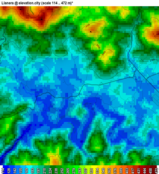
Below is the Elevation map of Llanera, which displays elevation range with different colors. Scale of the first map is from 114 to 472 m (374 to 1549 ft) with average elevation of 209.1 meters (=686 ft) [note 1]
These maps also provides idea of topography and contour of this city, they are displayed at different zoom levels. More info about maps, scale and edge coordinates you can find below images.
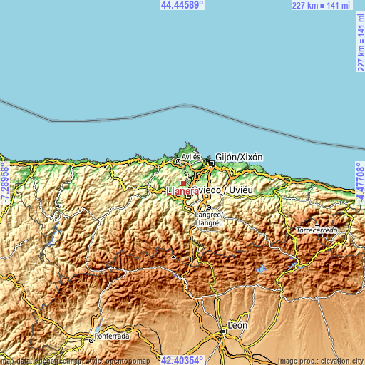
| \ | Map #1 | Topo.Map |
| Scale [m] | 114..472 m | × |
| Scale [ft] | 374..1549 ft | × |
| Average | 209.1 m = 686 ft | × |
| Width | 7.1 km = 4.4 mi | 227.1 km = 141.1 mi |
| Height | 7.1 km = 4.4 mi | 227.1 km = 141.1 mi |
| ↑Max Latitude | 43.465234° | 44.44589° |
| Latitude at center | 43.43333° | 43.43333° |
| ↓Min Latitude | 43.40141° | 42.40354° |
| ← Min Longitude | -5.927275° | -7.28958° |
| Longitude center | -5.88333° | -5.88333° |
| →Max Longitude | -5.839385° | -4.47708° |
Nearby cities:
Cities around Llanera sort by population:
• Oviedo elevation 237 m
8.7 km,  159°
159°
• Avilés 26 m
13.9 km,  346°
346°
• Corvera de Asturias 57 m
11.4 km,  357°
357°
• Lugones 169 m
6.7 km,  120°
120°
• Llanera 256 m
5 km,  309°
309°
• Pola de Siero 218 m
18.3 km,  104°
104°
• Grado 84 m
16.2 km,  251°
251°
• Piedras Blancas 28 m
15.8 km,  331°
331°
• Noreña 200 m
14.9 km,  107°
107°
• Castandiello 267 m
17.1 km,  182°
182°
• Illas 206 m
10.3 km, 313°
• Castrillón 113 m
15.5 km, 325°
Multilingual:
 En español:
Llanera elevación 161 m.
 En France:
Llanera élévation 161 m.


Sources and notes:
- [note 1] Map square and city borders are not equal. Map elevation data is calculated only from area inside that square.
- [src 1] Elevation data from geonames database provided with same terms of usage.
- [src 2] The elevation map of Llanera is generated using elevation data from NASA's 3 arcsec (90m) resolution SRTM data.
- [src 3] Base (background) map © OpenStreetMap contributors tiles are generated by Geofabrik and OpenTopoMap.
Copyright & License:
This Llanera Elevation Map is licensed under CC BY-SA. You may reuse any part from this page, if you give a proper credit by linking to this URL:
 More info on terms of use page.