Belmonte elevation
Belmonte (Asturias, Province of Asturias), Spain elevation is 203 meters and Belmonte elevation in feet is 666 ft above sea level [src 1]. Belmonte is a populated place (feature code) with elevation that is 400 meters (1312 ft) smaller than average city elevation in Spain.
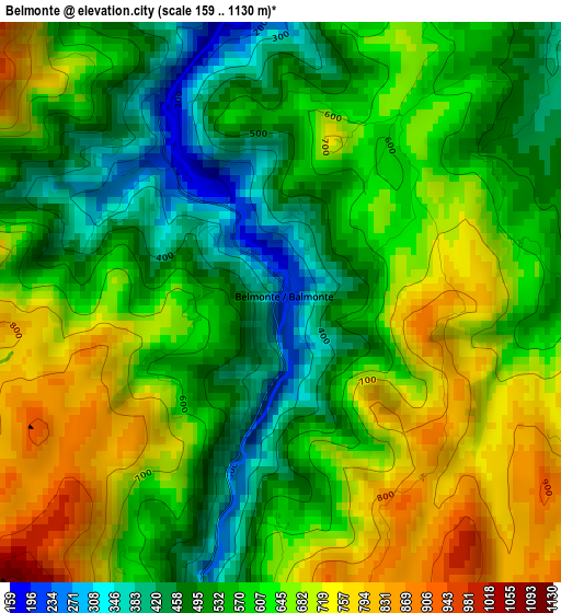
Below is the Elevation map of Belmonte, which displays elevation range with different colors. Scale of the first map is from 159 to 1130 m (522 to 3707 ft) with average elevation of 595.2 meters (=1953 ft) [note 1]
These maps also provides idea of topography and contour of this city, they are displayed at different zoom levels. More info about maps, scale and edge coordinates you can find below images.
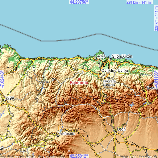
| \ | Map #1 | Topo.Map |
| Scale [m] | 159..1130 m | × |
| Scale [ft] | 522..3707 ft | × |
| Average | 595.2 m = 1953 ft | × |
| Width | 7.11 km = 4.4 mi | 227.7 km = 141.5 mi |
| Height | 7.11 km = 4.4 mi | 227.6 km = 141.4 mi |
| ↑Max Latitude | 43.314433° | 44.29756° |
| Latitude at center | 43.28245° | 43.28245° |
| ↓Min Latitude | 43.25045° | 42.25012° |
| ← Min Longitude | -6.262125° | -7.62443° |
| Longitude center | -6.21818° | -6.21818° |
| →Max Longitude | -6.174235° | -4.81193° |
Nearby cities:
Cities around Belmonte sort by population:
• Cangas del Narcea elevation 368 m
29.1 km,  247°
247°
• Tineo 704 m
17 km,  291°
291°
• Grado 84 m
16.5 km,  44°
44°
• Salas 297 m
14.8 km,  346°
346°
• Soto del Barco 61 m
30.3 km,  23°
23°
• Castandiello 267 m
26.4 km,  90°
90°
• Muros de Nalón 114 m
30.4 km, 17°
• La Plaza 506 m
16.3 km,  143°
143°
• Pola de Somiedo 697 m
21.3 km,  188°
188°
• Bárzana 447 m
24.2 km,  125°
125°
• Proaza 214 m
16.7 km,  101°
101°
• Pravia 48 m
24.5 km, 20°
Multilingual:
 En español:
Belmonte elevación 203 m.
 En France:
Belmonte élévation 203 m.
 Auf Deutsch:
Belmonte höhe über dem Meeresspiegel ist 203 m.

Sources and notes:
- [note 1] Map square and city borders are not equal. Map elevation data is calculated only from area inside that square.
- [src 1] Elevation data from geonames database provided with same terms of usage.
- [src 2] The elevation map of Belmonte is generated using elevation data from NASA's 3 arcsec (90m) resolution SRTM data.
- [src 3] Base (background) map © OpenStreetMap contributors tiles are generated by Geofabrik and OpenTopoMap.
Copyright & License:
This Belmonte Elevation Map is licensed under CC BY-SA. You may reuse any part from this page, if you give a proper credit by linking to this URL:
 More info on terms of use page.