Grávalos elevation
Grávalos (La Rioja, Provincia de La Rioja), Spain elevation is 738 meters and Grávalos elevation in feet is 2421 ft above sea level [src 1]. Grávalos is a seat of a third-order administrative division (feature code) with elevation that is 135 meters (443 ft) bigger than average city elevation in Spain.
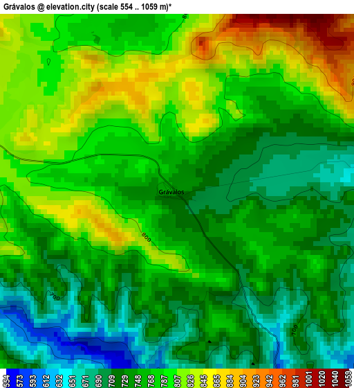
Below is the Elevation map of Grávalos, which displays elevation range with different colors. Scale of the first map is from 554 to 1059 m (1818 to 3474 ft) with average elevation of 764.1 meters (=2507 ft) [note 1]
These maps also provides idea of topography and contour of this city, they are displayed at different zoom levels. More info about maps, scale and edge coordinates you can find below images.
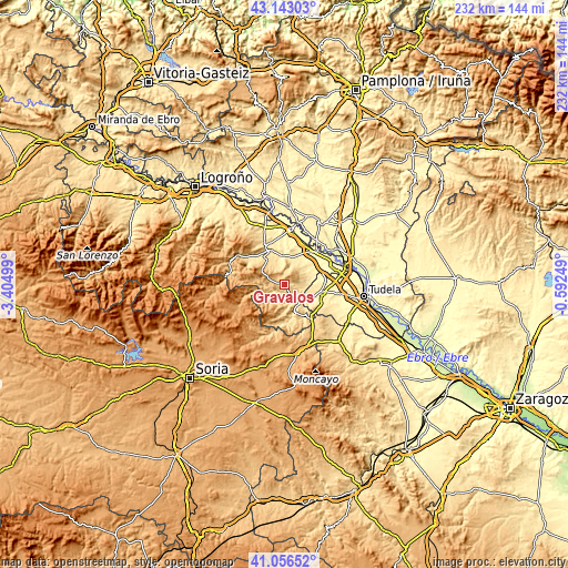
| \ | Map #1 | Topo.Map |
| Scale [m] | 554..1059 m | × |
| Scale [ft] | 1818..3474 ft | × |
| Average | 764.1 m = 2507 ft | × |
| Width | 7.25 km = 4.5 mi | 232 km = 144.2 mi |
| Height | 7.25 km = 4.5 mi | 232 km = 144.2 mi |
| ↑Max Latitude | 42.140954° | 43.14303° |
| Latitude at center | 42.10836° | 42.10836° |
| ↓Min Latitude | 42.07575° | 41.05652° |
| ← Min Longitude | -2.042685° | -3.40499° |
| Longitude center | -1.99874° | -1.99874° |
| →Max Longitude | -1.954795° | -0.59249° |
Nearby cities:
Cities around Grávalos sort by population:
• Arnedo elevation 531 m
15.7 km,  327°
327°
• Cintruénigo 400 m
16.3 km,  101°
101°
• Autol 434 m
12 km,  357°
357°
• Cervera del Río Alhama 539 m
12 km,  162°
162°
• Aldeanueva de Ebro 348 m
16.3 km,  34°
34°
• Fitero 427 m
12.9 km,  115°
115°
• Quel 483 m
14.2 km,  342°
342°
• Igea 570 m
4.6 km,  192°
192°
• Cornago 708 m
9.3 km,  238°
238°
• Muro de Aguas 893 m
9.7 km,  286°
286°
• Valdemadera 973 m
15.2 km,  204°
204°
• Villarroya 925 m
6.3 km, 293°
Multilingual:
 En español:
Grávalos elevación 738 m.
 En France:
Grávalos élévation 738 m.
 Auf Deutsch:
Grávalos höhe über dem Meeresspiegel ist 738 m.

Sources and notes:
- [note 1] Map square and city borders are not equal. Map elevation data is calculated only from area inside that square.
- [src 1] Elevation data from geonames database provided with same terms of usage.
- [src 2] The elevation map of Grávalos is generated using elevation data from NASA's 3 arcsec (90m) resolution SRTM data.
- [src 3] Base (background) map © OpenStreetMap contributors tiles are generated by Geofabrik and OpenTopoMap.
Copyright & License:
This Grávalos Elevation Map is licensed under CC BY-SA. You may reuse any part from this page, if you give a proper credit by linking to this URL:
 More info on terms of use page.