Langayo elevation
Langayo (Castille and León, Provincia de Valladolid), Spain elevation is 823 meters and Langayo elevation in feet is 2700 ft above sea level [src 1]. Langayo is a seat of a third-order administrative division (feature code) with elevation that is 220 meters (722 ft) bigger than average city elevation in Spain.
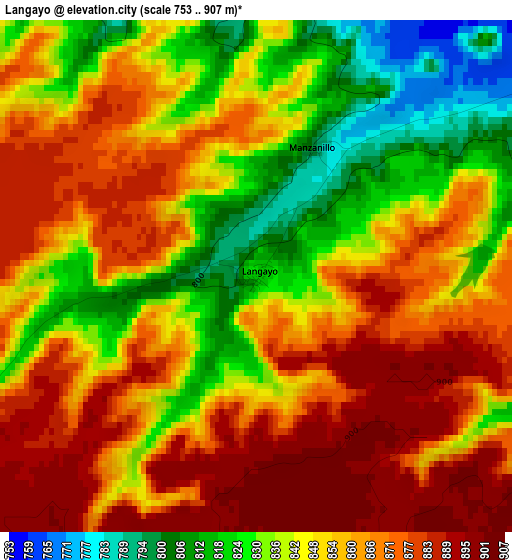
Below is the Elevation map of Langayo, which displays elevation range with different colors. Scale of the first map is from 753 to 907 m (2470 to 2976 ft) with average elevation of 853.2 meters (=2799 ft) [note 1]
These maps also provides idea of topography and contour of this city, they are displayed at different zoom levels. More info about maps, scale and edge coordinates you can find below images.
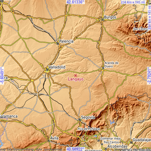
| \ | Map #1 | Topo.Map |
| Scale [m] | 753..907 m | × |
| Scale [ft] | 2470..2976 ft | × |
| Average | 853.2 m = 2799 ft | × |
| Width | 7.31 km = 4.5 mi | 234 km = 145.4 mi |
| Height | 7.31 km = 4.5 mi | 234 km = 145.4 mi |
| ↑Max Latitude | 41.602729° | 42.61336° |
| Latitude at center | 41.56986° | 41.56986° |
| ↓Min Latitude | 41.536974° | 40.50922° |
| ← Min Longitude | -4.242605° | -5.60491° |
| Longitude center | -4.19866° | -4.19866° |
| →Max Longitude | -4.154715° | -2.79241° |
Nearby cities:
Cities around Langayo sort by population:
• Peñafiel elevation 756 m
7.9 km,  63°
63°
• Campaspero 905 m
8.7 km,  178°
178°
• Cogeces del Monte 893 m
11.9 km,  236°
236°
• Valbuena de Duero 735 m
11.3 km,  316°
316°
• Canalejas de Peñafiel 903 m
8.5 km,  125°
125°
• Rábano 779 m
12.1 km,  109°
109°
• Quintanilla de Arriba 742 m
5.8 km,  344°
344°
• Bahabón 878 m
11.9 km,  214°
214°
• Fompedraza 902 m
5.9 km, 130°
• Curiel de Duero 810 m
11.5 km,  44°
44°
• Torre de Peñafiel 791 m
9.9 km, 112°
• Manzanillo 793 m
2 km,  25°
25°
Multilingual:
 En español:
Langayo elevación 823 m.
 En France:
Langayo élévation 823 m.


Sources and notes:
- [note 1] Map square and city borders are not equal. Map elevation data is calculated only from area inside that square.
- [src 1] Elevation data from geonames database provided with same terms of usage.
- [src 2] The elevation map of Langayo is generated using elevation data from NASA's 3 arcsec (90m) resolution SRTM data.
- [src 3] Base (background) map © OpenStreetMap contributors tiles are generated by Geofabrik and OpenTopoMap.
Copyright & License:
This Langayo Elevation Map is licensed under CC BY-SA. You may reuse any part from this page, if you give a proper credit by linking to this URL:
 More info on terms of use page.