Peñafiel elevation
Peñafiel (Castille and León, Provincia de Valladolid), Spain elevation is 756 meters and Peñafiel elevation in feet is 2480 ft above sea level [src 1]. Peñafiel is a seat of a third-order administrative division (feature code) with elevation that is 153 meters (502 ft) bigger than average city elevation in Spain.
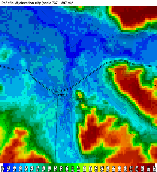
Below is the Elevation map of Peñafiel, which displays elevation range with different colors. Scale of the first map is from 737 to 897 m (2418 to 2943 ft) with average elevation of 785.9 meters (=2578 ft) [note 1]
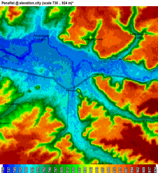
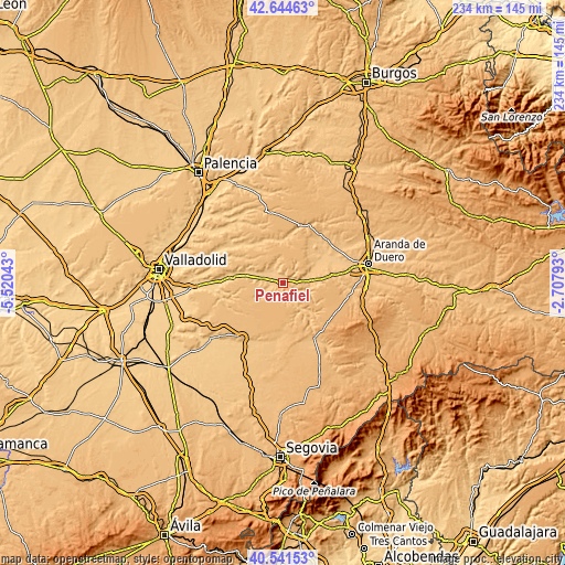
These maps also provides idea of topography and contour of this city, they are displayed at different zoom levels. More info about maps, scale and edge coordinates you can find below images.
| \ | Map #1 | Map #2 | Topo.Map |
| Scale [m] | 737..897 m | 730..924 m | × |
| Scale [ft] | 2418..2943 ft | 2395..3031 ft | × |
| Average | 785.9 m = 2578 ft | 822.8 m = 2699 ft | × |
| Width | 7.31 km = 4.5 mi | 14.62 km = 9.1 mi | 233.8 km = 145.3 mi |
| Height | 7.31 km = 4.5 mi | 14.62 km = 9.1 mi | 233.8 km = 145.3 mi |
| ↑Max Latitude | 41.634503° | 41.667339° | 42.64463° |
| Latitude at center | 41.60165° | 41.60165° | 41.60165° |
| ↓Min Latitude | 41.56878° | 41.535894° | 40.54153° |
| ← Min Longitude | -4.158125° | -4.202071° | -5.52043° |
| Longitude center | -4.11418° | -4.11418° | -4.11418° |
| →Max Longitude | -4.070235° | -4.026289° | -2.70793° |
Nearby cities:
Cities around Peñafiel sort by population:
• Langayo elevation 823 m
7.9 km,  243°
243°
• Canalejas de Peñafiel 903 m
8.5 km,  180°
180°
• Piñel de Abajo 790 m
8.5 km,  341°
341°
• Castrillo de Duero 801 m
8.7 km,  109°
109°
• Fompedraza 902 m
7.8 km,  199°
199°
• Valdearcos de la Vega 779 m
7.1 km,  50°
50°
• Curiel de Duero 810 m
4.8 km,  13°
13°
• Olmos de Peñafiel 790 m
6.8 km,  119°
119°
• Bocos de Duero 766 m
4.4 km,  56°
56°
• Torre de Peñafiel 791 m
7.6 km,  163°
163°
• Manzanillo 793 m
6.4 km,  254°
254°
• Roturas 827 m
7.4 km,  356°
356°
Multilingual:
 En español:
Peñafiel elevación 756 m.
 En France:
Peñafiel élévation 756 m.
 Auf Deutsch:
Peñafiel höhe über dem Meeresspiegel ist 756 m.

Sources and notes:
- [note 1] Map square and city borders are not equal. Map elevation data is calculated only from area inside that square.
- [src 1] Elevation data from geonames database provided with same terms of usage.
- [src 2] The elevation map of Peñafiel is generated using elevation data from NASA's 3 arcsec (90m) resolution SRTM data.
- [src 3] Base (background) map © OpenStreetMap contributors tiles are generated by Geofabrik and OpenTopoMap.
Copyright & License:
This Peñafiel Elevation Map is licensed under CC BY-SA. You may reuse any part from this page, if you give a proper credit by linking to this URL:
 More info on terms of use page.