Campaspero elevation
Campaspero (Castille and León, Provincia de Valladolid), Spain elevation is 905 meters and Campaspero elevation in feet is 2969 ft above sea level [src 1]. Campaspero is a seat of a third-order administrative division (feature code) with elevation that is 302 meters (991 ft) bigger than average city elevation in Spain.
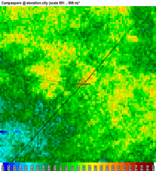
Below is the Elevation map of Campaspero, which displays elevation range with different colors. Scale of the first map is from 891 to 908 m (2923 to 2979 ft) with average elevation of 901.9 meters (=2959 ft) [note 1]
These maps also provides idea of topography and contour of this city, they are displayed at different zoom levels. More info about maps, scale and edge coordinates you can find below images.
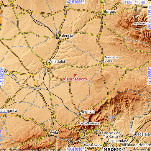
| \ | Map #1 | Topo.Map |
| Scale [m] | 891..908 m | × |
| Scale [ft] | 2923..2979 ft | × |
| Average | 901.9 m = 2959 ft | × |
| Width | 7.32 km = 4.5 mi | 234.2 km = 145.5 mi |
| Height | 7.32 km = 4.5 mi | 234.2 km = 145.5 mi |
| ↑Max Latitude | 41.524989° | 42.53685° |
| Latitude at center | 41.49208° | 41.49208° |
| ↓Min Latitude | 41.459155° | 40.43018° |
| ← Min Longitude | -4.240025° | -5.60233° |
| Longitude center | -4.19608° | -4.19608° |
| →Max Longitude | -4.152135° | -2.78983° |
Nearby cities:
Cities around Campaspero sort by population:
• Cogeces del Monte elevation 893 m
10.3 km,  281°
281°
• Olombrada 875 m
9.1 km,  161°
161°
• Langayo 823 m
8.7 km,  358°
358°
• Canalejas de Peñafiel 903 m
7.7 km,  61°
61°
• Bahabón 878 m
7 km,  260°
260°
• Torrescárcela 890 m
10.3 km,  265°
265°
• Fompedraza 902 m
6.4 km,  41°
41°
• Aldeasoña 850 m
11.8 km,  100°
100°
• Membibre de la Hoz 864 m
9.6 km,  119°
119°
• Torre de Peñafiel 791 m
10.2 km, 61°
• Manzanillo 793 m
10.5 km,  3°
3°
• Perosillo 833 m
11.9 km, 157°
Multilingual:
 En español:
Campaspero elevación 905 m.
 En France:
Campaspero élévation 905 m.
 Auf Deutsch:
Campaspero höhe über dem Meeresspiegel ist 905 m.

Sources and notes:
- [note 1] Map square and city borders are not equal. Map elevation data is calculated only from area inside that square.
- [src 1] Elevation data from geonames database provided with same terms of usage.
- [src 2] The elevation map of Campaspero is generated using elevation data from NASA's 3 arcsec (90m) resolution SRTM data.
- [src 3] Base (background) map © OpenStreetMap contributors tiles are generated by Geofabrik and OpenTopoMap.
Copyright & License:
This Campaspero Elevation Map is licensed under CC BY-SA. You may reuse any part from this page, if you give a proper credit by linking to this URL:
 More info on terms of use page.