La Robla elevation
La Robla (Castille and León, Provincia de León), Spain elevation is 955 meters and La Robla elevation in feet is 3133 ft above sea level [src 1]. La Robla is a populated place (feature code) with elevation that is 352 meters (1155 ft) bigger than average city elevation in Spain.
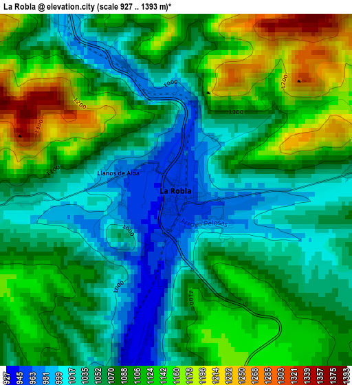
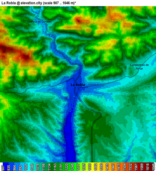
Below is the Elevation map of La Robla, which displays elevation range with different colors. Scale of the first map is from 927 to 1393 m (3041 to 4570 ft) with average elevation of 1084.8 meters (=3559 ft) [note 1]
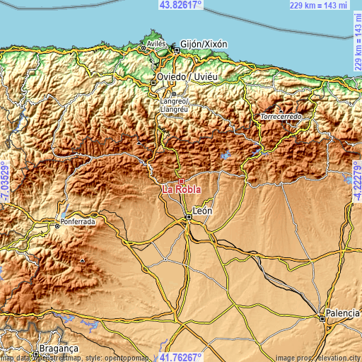
These maps also provides idea of topography and contour of this city, they are displayed at different zoom levels. More info about maps, scale and edge coordinates you can find below images.
| \ | Map #1 | Map #2 | Topo.Map |
| Scale [m] | 927..1393 m | 907..1646 m | × |
| Scale [ft] | 3041..4570 ft | 2976..5400 ft | × |
| Average | 1084.8 m = 3559 ft | 1137.2 m = 3731 ft | × |
| Width | 7.17 km = 4.5 mi | 14.34 km = 8.9 mi | 229.4 km = 142.5 mi |
| Height | 7.17 km = 4.5 mi | 14.34 km = 8.9 mi | 229.4 km = 142.5 mi |
| ↑Max Latitude | 42.835254° | 42.867471° | 43.82617° |
| Latitude at center | 42.80302° | 42.80302° | 42.80302° |
| ↓Min Latitude | 42.770769° | 42.738502° | 41.76267° |
| ← Min Longitude | -5.672985° | -5.716931° | -7.03529° |
| Longitude center | -5.62904° | -5.62904° | -5.62904° |
| →Max Longitude | -5.585095° | -5.541149° | -4.22279° |
Nearby cities:
Cities around La Robla sort by population:
• Villaquilambre elevation 893 m
18.3 km,  161°
161°
• La Pola de Gordón 1075 m
6.7 km,  332°
332°
• Sariegos 871 m
17 km,  181°
181°
• Cuadros 901 m
10.2 km, 184°
• Matallana de Torío 1020 m
11.3 km,  51°
51°
• Villamanín 1134 m
15.2 km,  351°
351°
• Garrafe de Torío 916 m
11.6 km,  132°
132°
• Santa Colomba de Curueño 927 m
18.6 km,  108°
108°
• Carrocera 1050 m
9.4 km,  265°
265°
• Cármenes 1162 m
17.9 km,  14°
14°
• Santa María de Ordás 950 m
18 km,  241°
241°
• Vegacervera 1057 m
12.1 km,  38°
38°
Multilingual:
 En español:
La Robla elevación 955 m.
 En France:
La Robla élévation 955 m.
 Auf Deutsch:
La Robla höhe über dem Meeresspiegel ist 955 m.

Sources and notes:
- [note 1] Map square and city borders are not equal. Map elevation data is calculated only from area inside that square.
- [src 1] Elevation data from geonames database provided with same terms of usage.
- [src 2] The elevation map of La Robla is generated using elevation data from NASA's 3 arcsec (90m) resolution SRTM data.
- [src 3] Base (background) map © OpenStreetMap contributors tiles are generated by Geofabrik and OpenTopoMap.
Copyright & License:
This La Robla Elevation Map is licensed under CC BY-SA. You may reuse any part from this page, if you give a proper credit by linking to this URL:
 More info on terms of use page.