Sariegos elevation
Sariegos (Castille and León, Provincia de León), Spain elevation is 871 meters and Sariegos elevation in feet is 2858 ft above sea level [src 1]. Sariegos is a populated place (feature code) with elevation that is 268 meters (879 ft) bigger than average city elevation in Spain.
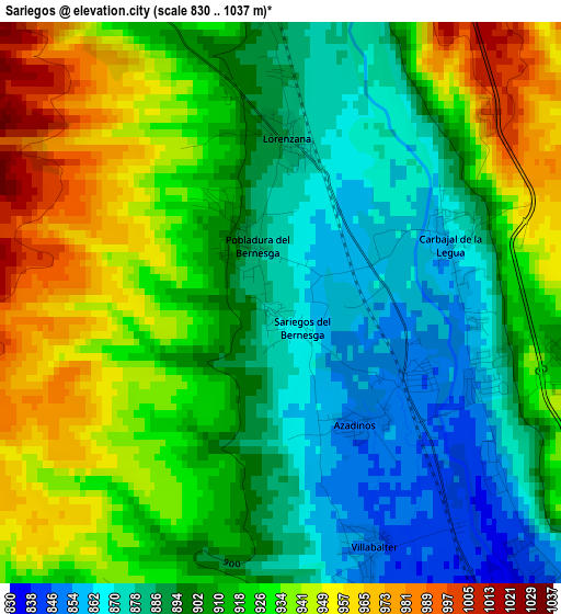
Below is the Elevation map of Sariegos, which displays elevation range with different colors. Scale of the first map is from 830 to 1037 m (2723 to 3402 ft) with average elevation of 911.6 meters (=2991 ft) [note 1]
These maps also provides idea of topography and contour of this city, they are displayed at different zoom levels. More info about maps, scale and edge coordinates you can find below images.
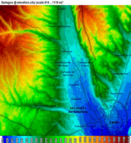
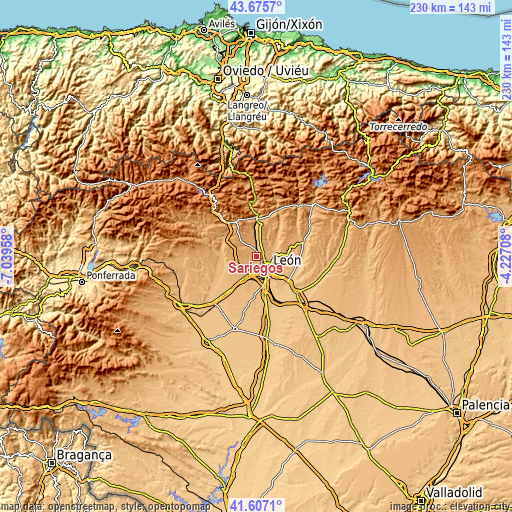
| \ | Map #1 | Map #2 | Topo.Map |
| Scale [m] | 830..1037 m | 814..1118 m | × |
| Scale [ft] | 2723..3402 ft | 2671..3668 ft | × |
| Average | 911.6 m = 2991 ft | 938.3 m = 3078 ft | × |
| Width | 7.19 km = 4.5 mi | 14.38 km = 8.9 mi | 230 km = 142.9 mi |
| Height | 7.19 km = 4.5 mi | 14.38 km = 8.9 mi | 230 km = 142.9 mi |
| ↑Max Latitude | 42.682314° | 42.71461° | 43.6757° |
| Latitude at center | 42.65° | 42.65° | 42.65° |
| ↓Min Latitude | 42.61767° | 42.585322° | 41.6071° |
| ← Min Longitude | -5.677275° | -5.721221° | -7.03958° |
| Longitude center | -5.63333° | -5.63333° | -5.63333° |
| →Max Longitude | -5.589385° | -5.545439° | -4.22708° |
Nearby cities:
Cities around Sariegos sort by population:
• León elevation 844 m
7.6 km,  137°
137°
• San Andrés del Rabanedo 852 m
4.5 km,  162°
162°
• Villaquilambre 893 m
6.1 km,  93°
93°
• Valverde de la Virgen 894 m
10 km,  204°
204°
• La Robla 955 m
17 km,  1°
1°
• Chozas de Abajo 882 m
16.5 km, 195°
• Valdefresno 872 m
13 km,  118°
118°
• Cuadros 901 m
6.9 km,  356°
356°
• Onzonilla 808 m
14.6 km, 163°
• Garrafe de Torío 916 m
12.9 km,  44°
44°
• Llamas de la Ribera 898 m
15.8 km,  263°
263°
• Cimanes del Tejar 903 m
14.5 km, 255°
Multilingual:
 En español:
Sariegos elevación 871 m.
 En France:
Sariegos élévation 871 m.
 Auf Deutsch:
Sariegos höhe über dem Meeresspiegel ist 871 m.

Sources and notes:
- [note 1] Map square and city borders are not equal. Map elevation data is calculated only from area inside that square.
- [src 1] Elevation data from geonames database provided with same terms of usage.
- [src 2] The elevation map of Sariegos is generated using elevation data from NASA's 3 arcsec (90m) resolution SRTM data.
- [src 3] Base (background) map © OpenStreetMap contributors tiles are generated by Geofabrik and OpenTopoMap.
Copyright & License:
This Sariegos Elevation Map is licensed under CC BY-SA. You may reuse any part from this page, if you give a proper credit by linking to this URL:
 More info on terms of use page.