La Seca elevation
La Seca (Castille and León, Provincia de Valladolid), Spain elevation is 735 meters and La Seca elevation in feet is 2411 ft above sea level [src 1]. La Seca is a populated place (feature code) with elevation that is 132 meters (433 ft) bigger than average city elevation in Spain.
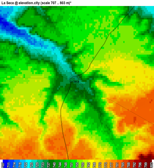
Below is the Elevation map of La Seca, which displays elevation range with different colors. Scale of the first map is from 707 to 803 m (2320 to 2635 ft) with average elevation of 755.7 meters (=2479 ft) [note 1]
These maps also provides idea of topography and contour of this city, they are displayed at different zoom levels. More info about maps, scale and edge coordinates you can find below images.
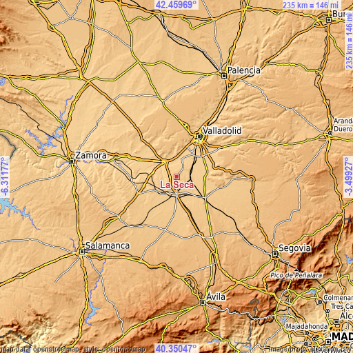
| \ | Map #1 | Topo.Map |
| Scale [m] | 707..803 m | × |
| Scale [ft] | 2320..2635 ft | × |
| Average | 755.7 m = 2479 ft | × |
| Width | 7.33 km = 4.6 mi | 234.5 km = 145.7 mi |
| Height | 7.33 km = 4.6 mi | 234.5 km = 145.7 mi |
| ↑Max Latitude | 41.446589° | 42.45969° |
| Latitude at center | 41.41364° | 41.41364° |
| ↓Min Latitude | 41.380675° | 40.35047° |
| ← Min Longitude | -4.949465° | -6.31177° |
| Longitude center | -4.90552° | -4.90552° |
| →Max Longitude | -4.861575° | -3.49927° |
Nearby cities:
Cities around La Seca sort by population:
• Medina del Campo elevation 721 m
11.3 km,  183°
183°
• Tordesillas 705 m
12.7 km,  320°
320°
• Valdestillas 702 m
13.2 km,  57°
57°
• Rueda 729 m
4.4 km,  268°
268°
• Serrada 725 m
6 km,  36°
36°
• Villanueva de Duero 693 m
12.2 km,  15°
15°
• Matapozuelos 729 m
9.5 km,  89°
89°
• Villaverde de Medina 734 m
15.6 km,  220°
220°
• Pozal de Gallinas 732 m
12 km,  152°
152°
• San Miguel del Pino 677 m
10.7 km,  357°
357°
• Ventosa de la Cuesta 765 m
6.4 km, 92°
• Matilla de los Caños 751 m
15.8 km,  340°
340°
Multilingual:
 En español:
La Seca elevación 735 m.
 En France:
La Seca élévation 735 m.


Sources and notes:
- [note 1] Map square and city borders are not equal. Map elevation data is calculated only from area inside that square.
- [src 1] Elevation data from geonames database provided with same terms of usage.
- [src 2] The elevation map of La Seca is generated using elevation data from NASA's 3 arcsec (90m) resolution SRTM data.
- [src 3] Base (background) map © OpenStreetMap contributors tiles are generated by Geofabrik and OpenTopoMap.
Copyright & License:
This La Seca Elevation Map is licensed under CC BY-SA. You may reuse any part from this page, if you give a proper credit by linking to this URL:
 More info on terms of use page.