Medina del Campo elevation
Medina del Campo (Castille and León, Provincia de Valladolid), Spain elevation is 721 meters and Medina del Campo elevation in feet is 2365 ft above sea level [src 1]. Medina del Campo is a seat of a third-order administrative division (feature code) with elevation that is 118 meters (387 ft) bigger than average city elevation in Spain.
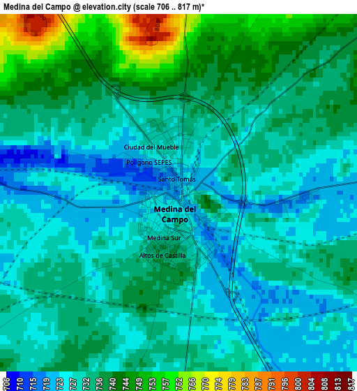
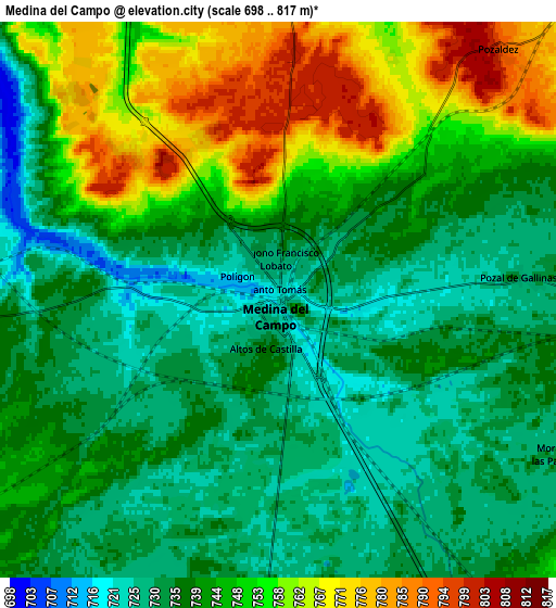
Below is the Elevation map of Medina del Campo, which displays elevation range with different colors. Scale of the first map is from 706 to 817 m (2316 to 2680 ft) with average elevation of 733.3 meters (=2406 ft) [note 1]
These maps also provides idea of topography and contour of this city, they are displayed at different zoom levels. More info about maps, scale and edge coordinates you can find below images.
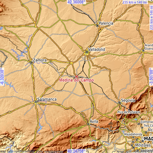
| \ | Map #1 | Map #2 | Topo.Map |
| Scale [m] | 706..817 m | 698..817 m | × |
| Scale [ft] | 2316..2680 ft | 2290..2680 ft | × |
| Average | 733.3 m = 2406 ft | 743 m = 2438 ft | × |
| Width | 7.34 km = 4.6 mi | 14.68 km = 9.1 mi | 234.9 km = 146 mi |
| Height | 7.34 km = 4.6 mi | 14.68 km = 9.1 mi | 234.9 km = 146 mi |
| ↑Max Latitude | 41.34539° | 41.378373° | 42.36008° |
| Latitude at center | 41.31239° | 41.31239° | 41.31239° |
| ↓Min Latitude | 41.279373° | 41.24634° | 40.24758° |
| ← Min Longitude | -4.958075° | -5.002021° | -6.32038° |
| Longitude center | -4.91413° | -4.91413° | -4.91413° |
| →Max Longitude | -4.870185° | -4.826239° | -3.50788° |
Nearby cities:
Cities around Medina del Campo sort by population:
• Nava del Rey elevation 751 m
14.1 km,  278°
278°
• Rueda 729 m
11.7 km,  341°
341°
• La Seca 735 m
11.3 km,  3°
3°
• Villaverde de Medina 734 m
9.4 km,  266°
266°
• Pozal de Gallinas 732 m
6.3 km,  83°
83°
• Nueva Villa de las Torres 745 m
12.9 km,  247°
247°
• Rubí de Bracamonte 753 m
11 km,  184°
184°
• San Vicente del Palacio 747 m
11.6 km,  153°
153°
• Velascálvaro 745 m
10.3 km,  208°
208°
• Ventosa de la Cuesta 765 m
13.1 km,  32°
32°
• Ramiro 761 m
14.2 km,  131°
131°
• Moraleja de las Panaderas 732 m
8.4 km,  118°
118°
Multilingual:
 En español:
Medina del Campo elevación 721 m.
 En France:
Medina del Campo élévation 721 m.
 Auf Deutsch:
Medina del Campo höhe über dem Meeresspiegel ist 721 m.

Sources and notes:
- [note 1] Map square and city borders are not equal. Map elevation data is calculated only from area inside that square.
- [src 1] Elevation data from geonames database provided with same terms of usage.
- [src 2] The elevation map of Medina del Campo is generated using elevation data from NASA's 3 arcsec (90m) resolution SRTM data.
- [src 3] Base (background) map © OpenStreetMap contributors tiles are generated by Geofabrik and OpenTopoMap.
Copyright & License:
This Medina del Campo Elevation Map is licensed under CC BY-SA. You may reuse any part from this page, if you give a proper credit by linking to this URL:
 More info on terms of use page.