Rueda elevation
Rueda (Castille and León, Provincia de Valladolid), Spain elevation is 729 meters and Rueda elevation in feet is 2392 ft above sea level [src 1]. Rueda is a seat of a third-order administrative division (feature code) with elevation that is 126 meters (413 ft) bigger than average city elevation in Spain.
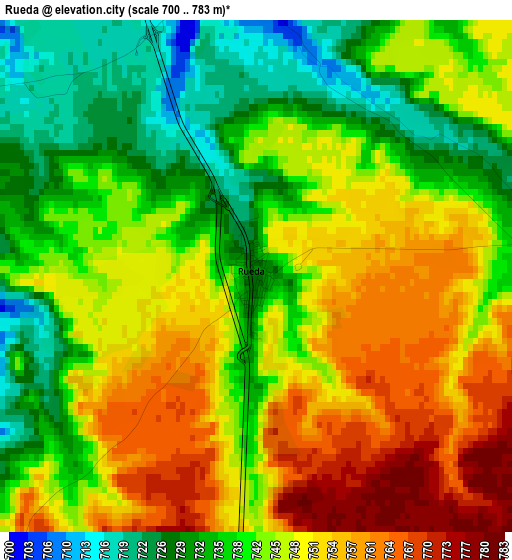
Below is the Elevation map of Rueda, which displays elevation range with different colors. Scale of the first map is from 700 to 783 m (2297 to 2569 ft) with average elevation of 744.2 meters (=2442 ft) [note 1]
These maps also provides idea of topography and contour of this city, they are displayed at different zoom levels. More info about maps, scale and edge coordinates you can find below images.
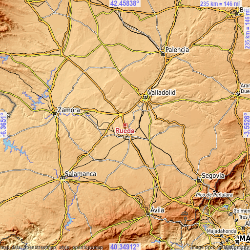
| \ | Map #1 | Topo.Map |
| Scale [m] | 700..783 m | × |
| Scale [ft] | 2297..2569 ft | × |
| Average | 744.2 m = 2442 ft | × |
| Width | 7.33 km = 4.6 mi | 234.5 km = 145.7 mi |
| Height | 7.33 km = 4.6 mi | 234.5 km = 145.7 mi |
| ↑Max Latitude | 41.445259° | 42.45838° |
| Latitude at center | 41.41231° | 41.41231° |
| ↓Min Latitude | 41.379344° | 40.34912° |
| ← Min Longitude | -5.002795° | -6.3651° |
| Longitude center | -4.95885° | -4.95885° |
| →Max Longitude | -4.914905° | -3.5526° |
Nearby cities:
Cities around Rueda sort by population:
• Medina del Campo elevation 721 m
11.7 km,  161°
161°
• Tordesillas 705 m
10.6 km,  340°
340°
• Nava del Rey 751 m
13.7 km,  228°
228°
• Serrada 725 m
9.4 km,  58°
58°
• Villanueva de Duero 693 m
14.2 km,  32°
32°
• La Seca 735 m
4.4 km,  88°
88°
• Matapozuelos 729 m
14 km, 89°
• Pollos 676 m
14.3 km,  284°
284°
• Villaverde de Medina 734 m
13 km,  205°
205°
• Torrecilla de la Abadesa 676 m
13.4 km,  306°
306°
• San Miguel del Pino 677 m
11.5 km,  20°
20°
• Ventosa de la Cuesta 765 m
10.8 km, 90°
Multilingual:
 En español:
Rueda elevación 729 m.
 En France:
Rueda élévation 729 m.


Sources and notes:
- [note 1] Map square and city borders are not equal. Map elevation data is calculated only from area inside that square.
- [src 1] Elevation data from geonames database provided with same terms of usage.
- [src 2] The elevation map of Rueda is generated using elevation data from NASA's 3 arcsec (90m) resolution SRTM data.
- [src 3] Base (background) map © OpenStreetMap contributors tiles are generated by Geofabrik and OpenTopoMap.
Copyright & License:
This Rueda Elevation Map is licensed under CC BY-SA. You may reuse any part from this page, if you give a proper credit by linking to this URL:
 More info on terms of use page.