Lekunberri elevation
Lekunberri (Navarre, Provincia de Navarra), Spain elevation is 566 meters and Lekunberri elevation in feet is 1857 ft above sea level [src 1]. Lekunberri is a seat of a third-order administrative division (feature code) with elevation that is 37 meters (121 ft) smaller than average city elevation in Spain.
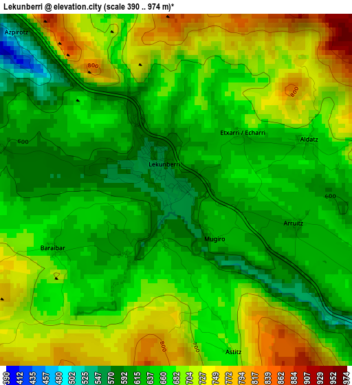
Below is the Elevation map of Lekunberri, which displays elevation range with different colors. Scale of the first map is from 390 to 974 m (1280 to 3196 ft) with average elevation of 668.6 meters (=2194 ft) [note 1]
These maps also provides idea of topography and contour of this city, they are displayed at different zoom levels. More info about maps, scale and edge coordinates you can find below images.
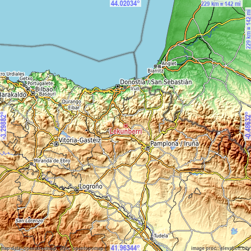
| \ | Map #1 | Topo.Map |
| Scale [m] | 390..974 m | × |
| Scale [ft] | 1280..3196 ft | × |
| Average | 668.6 m = 2194 ft | × |
| Width | 7.15 km = 4.4 mi | 228.7 km = 142.1 mi |
| Height | 7.15 km = 4.4 mi | 228.7 km = 142.1 mi |
| ↑Max Latitude | 43.032631° | 44.02034° |
| Latitude at center | 43.0005° | 43.0005° |
| ↓Min Latitude | 42.968352° | 41.96344° |
| ← Min Longitude | -1.936515° | -3.29882° |
| Longitude center | -1.89257° | -1.89257° |
| →Max Longitude | -1.848625° | -0.48632° |
Nearby cities:
Cities around Lekunberri sort by population:
• Arbizu elevation 494 m
15.2 km,  231°
231°
• Betelu 242 m
7.7 km,  291°
291°
• Areso 493 m
10.3 km,  331°
331°
• Irañeta 463 m
9.7 km,  206°
206°
• Saldías 555 m
13.4 km,  43°
43°
• Arruazu 469 m
12.5 km, 225°
• Orexa 414 m
14.2 km,  317°
317°
• Lakuntza 491 m
13.7 km, 230°
• Eratsun 519 m
11.9 km, 39°
• Ezkurra 513 m
11.1 km,  33°
33°
• Irurtzun 443 m
10.5 km,  152°
152°
• Leitza 471 m
9.4 km,  347°
347°
Multilingual:
 En español:
Lecumberri elevación 566 m.
 En France:
Lekunberri élévation 566 m.
 Auf Deutsch:
Lekunberri höhe über dem Meeresspiegel ist 566 m.

Sources and notes:
- [note 1] Map square and city borders are not equal. Map elevation data is calculated only from area inside that square.
- [src 1] Elevation data from geonames database provided with same terms of usage.
- [src 2] The elevation map of Lekunberri is generated using elevation data from NASA's 3 arcsec (90m) resolution SRTM data.
- [src 3] Base (background) map © OpenStreetMap contributors tiles are generated by Geofabrik and OpenTopoMap.
Copyright & License:
This Lekunberri Elevation Map is licensed under CC BY-SA. You may reuse any part from this page, if you give a proper credit by linking to this URL:
 More info on terms of use page.