Saldías elevation
Saldías (Navarre, Provincia de Navarra), Spain elevation is 555 meters and Saldías elevation in feet is 1821 ft above sea level [src 1]. Saldías is a seat of a third-order administrative division (feature code) with elevation that is 48 meters (157 ft) smaller than average city elevation in Spain.
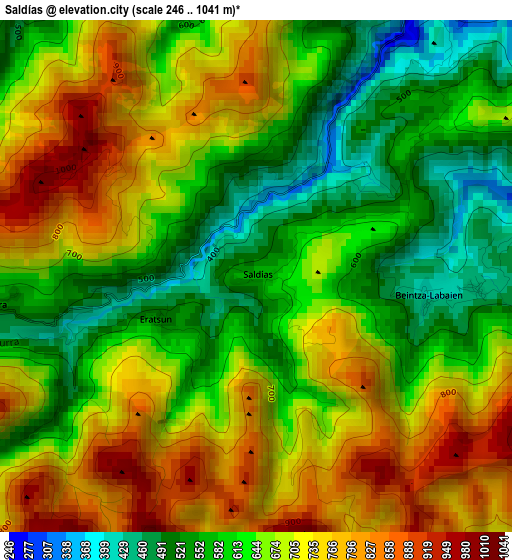
Below is the Elevation map of Saldías, which displays elevation range with different colors. Scale of the first map is from 246 to 1041 m (807 to 3415 ft) with average elevation of 664.3 meters (=2179 ft) [note 1]
These maps also provides idea of topography and contour of this city, they are displayed at different zoom levels. More info about maps, scale and edge coordinates you can find below images.
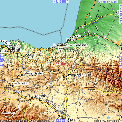
| \ | Map #1 | Topo.Map |
| Scale [m] | 246..1041 m | × |
| Scale [ft] | 807..3415 ft | × |
| Average | 664.3 m = 2179 ft | × |
| Width | 7.14 km = 4.4 mi | 228.4 km = 141.9 mi |
| Height | 7.14 km = 4.4 mi | 228.4 km = 141.9 mi |
| ↑Max Latitude | 43.120665° | 44.10695° |
| Latitude at center | 43.08858° | 43.08858° |
| ↓Min Latitude | 43.056478° | 42.053° |
| ← Min Longitude | -1.823405° | -3.18571° |
| Longitude center | -1.77946° | -1.77946° |
| →Max Longitude | -1.735515° | -0.37321° |
Nearby cities:
Cities around Saldías sort by population:
• Doneztebe elevation 122 m
10.4 km,  61°
61°
• Goizueta 158 m
11.5 km,  323°
323°
• Ituren 196 m
6.8 km,  44°
44°
• Zubieta 209 m
5 km, 36°
• Elgorriaga 139 m
9.4 km,  53°
53°
• Lekunberri 566 m
13.4 km,  223°
223°
• Arantza 284 m
12.8 km,  20°
20°
• Sunbilla 202 m
12.6 km, 46°
• Leitza 471 m
11.2 km,  267°
267°
• Oitz 246 m
8.4 km,  68°
68°
• Ezkurra 513 m
3.1 km,  259°
259°
• Eratsun 519 m
1.8 km,  250°
250°
Multilingual:
 En español:
Saldías elevación 555 m.
 En France:
Saldías élévation 555 m.


Sources and notes:
- [note 1] Map square and city borders are not equal. Map elevation data is calculated only from area inside that square.
- [src 1] Elevation data from geonames database provided with same terms of usage.
- [src 2] The elevation map of Saldías is generated using elevation data from NASA's 3 arcsec (90m) resolution SRTM data.
- [src 3] Base (background) map © OpenStreetMap contributors tiles are generated by Geofabrik and OpenTopoMap.
Copyright & License:
This Saldías Elevation Map is licensed under CC BY-SA. You may reuse any part from this page, if you give a proper credit by linking to this URL:
 More info on terms of use page.