Betelu elevation
Betelu (Navarre, Provincia de Navarra), Spain elevation is 242 meters and Betelu elevation in feet is 794 ft above sea level [src 1]. Betelu is a seat of a third-order administrative division (feature code) with elevation that is 361 meters (1184 ft) smaller than average city elevation in Spain.
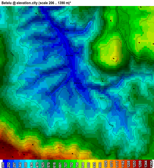
Below is the Elevation map of Betelu, which displays elevation range with different colors. Scale of the first map is from 206 to 1390 m (676 to 4560 ft) with average elevation of 523.3 meters (=1717 ft) [note 1]
These maps also provides idea of topography and contour of this city, they are displayed at different zoom levels. More info about maps, scale and edge coordinates you can find below images.
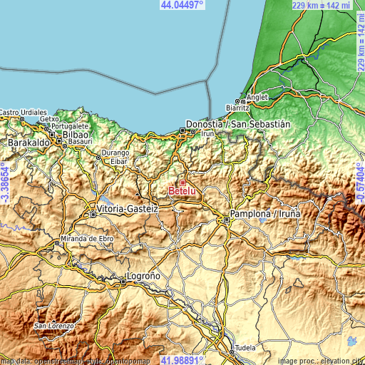
| \ | Map #1 | Topo.Map |
| Scale [m] | 206..1390 m | × |
| Scale [ft] | 676..4560 ft | × |
| Average | 523.3 m = 1717 ft | × |
| Width | 7.14 km = 4.4 mi | 228.6 km = 142 mi |
| Height | 7.14 km = 4.4 mi | 228.6 km = 142 mi |
| ↑Max Latitude | 43.057668° | 44.04497° |
| Latitude at center | 43.02555° | 43.02555° |
| ↓Min Latitude | 42.993415° | 41.98891° |
| ← Min Longitude | -2.024235° | -3.38654° |
| Longitude center | -1.98029° | -1.98029° |
| →Max Longitude | -1.936345° | -0.57404° |
Nearby cities:
Cities around Betelu sort by population:
• Areso elevation 493 m
6.7 km,  20°
20°
• Irañeta 463 m
11.8 km,  166°
166°
• Gaztelu 455 m
10.7 km,  340°
340°
• Arruazu 469 m
11.7 km,  188°
188°
• Lakuntza 491 m
12 km,  197°
197°
• Berastegi 402 m
11 km,  0°
0°
• Abaltzisketa 369 m
10.4 km,  283°
283°
• Lizartza 140 m
9.6 km,  332°
332°
• Amezketa 245 m
8.9 km,  286°
286°
• Leitza 471 m
8.2 km,  38°
38°
• Orexa 414 m
8 km, 341°
• Lekunberri 566 m
7.7 km,  111°
111°
Multilingual:
 En español:
Betelu elevación 242 m.
 En France:
Betelu élévation 242 m.


Sources and notes:
- [note 1] Map square and city borders are not equal. Map elevation data is calculated only from area inside that square.
- [src 1] Elevation data from geonames database provided with same terms of usage.
- [src 2] The elevation map of Betelu is generated using elevation data from NASA's 3 arcsec (90m) resolution SRTM data.
- [src 3] Base (background) map © OpenStreetMap contributors tiles are generated by Geofabrik and OpenTopoMap.
Copyright & License:
This Betelu Elevation Map is licensed under CC BY-SA. You may reuse any part from this page, if you give a proper credit by linking to this URL:
 More info on terms of use page.