Leganiel elevation
Leganiel (Castille-La Mancha, Provincia de Cuenca), Spain elevation is 753 meters and Leganiel elevation in feet is 2470 ft above sea level [src 1]. Leganiel is a seat of a third-order administrative division (feature code) with elevation that is 150 meters (492 ft) bigger than average city elevation in Spain.
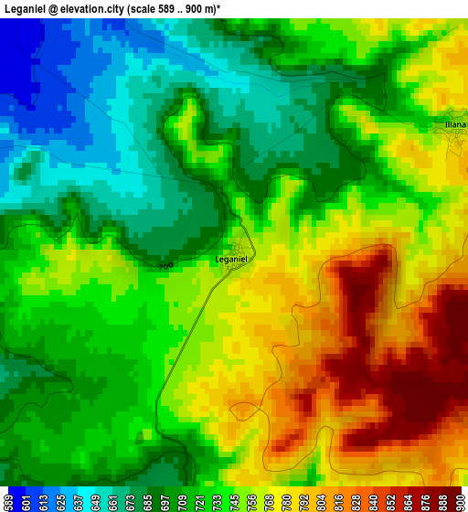
Below is the Elevation map of Leganiel, which displays elevation range with different colors. Scale of the first map is from 589 to 900 m (1932 to 2953 ft) with average elevation of 734.7 meters (=2410 ft) [note 1]
These maps also provides idea of topography and contour of this city, they are displayed at different zoom levels. More info about maps, scale and edge coordinates you can find below images.
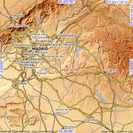
| \ | Map #1 | Topo.Map |
| Scale [m] | 589..900 m | × |
| Scale [ft] | 1932..2953 ft | × |
| Average | 734.7 m = 2410 ft | × |
| Width | 7.47 km = 4.6 mi | 239 km = 148.5 mi |
| Height | 7.47 km = 4.6 mi | 239 km = 148.5 mi |
| ↑Max Latitude | 40.199254° | 41.23179° |
| Latitude at center | 40.16568° | 40.16568° |
| ↓Min Latitude | 40.132089° | 39.08256° |
| ← Min Longitude | -2.993605° | -4.35591° |
| Longitude center | -2.94966° | -2.94966° |
| →Max Longitude | -2.905715° | -1.54341° |
Nearby cities:
Cities around Leganiel sort by population:
• Estremera elevation 626 m
12.9 km,  278°
278°
• Barajas de Melo 716 m
5.5 km,  149°
149°
• Illana 746 m
4 km,  58°
58°
• Brea de Tajo 676 m
14.8 km,  300°
300°
• Driebes 729 m
11.8 km,  318°
318°
• Mazuecos 700 m
11.6 km,  334°
334°
• Belinchón 716 m
16 km,  213°
213°
• Vellisca 943 m
12.2 km,  109°
109°
• Saceda-Trasierra 916 m
8.2 km,  98°
98°
• Paredes 835 m
13.8 km,  143°
143°
• Huelves 822 m
14.7 km,  157°
157°
• Almoguera 660 m
14.9 km,  349°
349°
Multilingual:
 En español:
Leganiel elevación 753 m.
 En France:
Leganiel élévation 753 m.
 Auf Deutsch:
Leganiel höhe über dem Meeresspiegel ist 753 m.

Sources and notes:
- [note 1] Map square and city borders are not equal. Map elevation data is calculated only from area inside that square.
- [src 1] Elevation data from geonames database provided with same terms of usage.
- [src 2] The elevation map of Leganiel is generated using elevation data from NASA's 3 arcsec (90m) resolution SRTM data.
- [src 3] Base (background) map © OpenStreetMap contributors tiles are generated by Geofabrik and OpenTopoMap.
Copyright & License:
This Leganiel Elevation Map is licensed under CC BY-SA. You may reuse any part from this page, if you give a proper credit by linking to this URL:
 More info on terms of use page.