Mazuecos elevation
Mazuecos (Castille-La Mancha, Provincia de Guadalajara), Spain elevation is 700 meters and Mazuecos elevation in feet is 2297 ft above sea level [src 1]. Mazuecos is a seat of a third-order administrative division (feature code) with elevation that is 97 meters (318 ft) bigger than average city elevation in Spain.
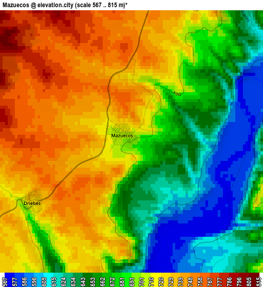
Below is the Elevation map of Mazuecos, which displays elevation range with different colors. Scale of the first map is from 567 to 815 m (1860 to 2674 ft) with average elevation of 692.1 meters (=2271 ft) [note 1]
These maps also provides idea of topography and contour of this city, they are displayed at different zoom levels. More info about maps, scale and edge coordinates you can find below images.
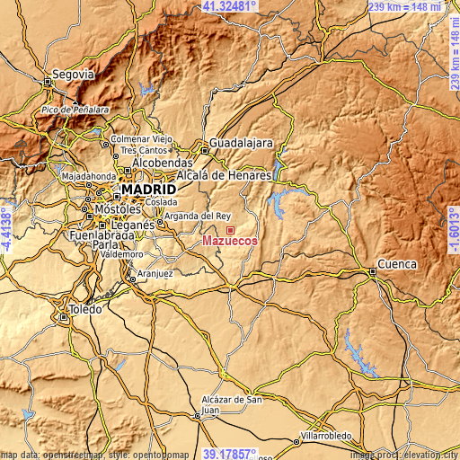
| \ | Map #1 | Topo.Map |
| Scale [m] | 567..815 m | × |
| Scale [ft] | 1860..2674 ft | × |
| Average | 692.1 m = 2271 ft | × |
| Width | 7.46 km = 4.6 mi | 238.6 km = 148.3 mi |
| Height | 7.46 km = 4.6 mi | 238.6 km = 148.3 mi |
| ↑Max Latitude | 40.293727° | 41.32481° |
| Latitude at center | 40.2602° | 40.2602° |
| ↓Min Latitude | 40.226656° | 39.17857° |
| ← Min Longitude | -3.051495° | -4.4138° |
| Longitude center | -3.00755° | -3.00755° |
| →Max Longitude | -2.963605° | -1.6013° |
Nearby cities:
Cities around Mazuecos sort by population:
• Mondéjar elevation 821 m
10.8 km,  308°
308°
• Estremera 626 m
11.6 km,  222°
222°
• Illana 746 m
11.9 km,  135°
135°
• Albares 729 m
5.2 km,  358°
358°
• Yebra 750 m
11.3 km,  17°
17°
• Brea de Tajo 676 m
8.4 km,  249°
249°
• Fuentenovilla 798 m
13.4 km,  328°
328°
• Driebes 729 m
3.4 km,  239°
239°
• Leganiel 753 m
11.6 km,  154°
154°
• Pozo de Almoguera 794 m
9 km,  349°
349°
• Zorita de los Canes 612 m
12.8 km,  52°
52°
• Almoguera 660 m
4.6 km,  27°
27°
Multilingual:
 En español:
Mazuecos elevación 700 m.
 En France:
Mazuecos élévation 700 m.
 Auf Deutsch:
Mazuecos höhe über dem Meeresspiegel ist 700 m.

Sources and notes:
- [note 1] Map square and city borders are not equal. Map elevation data is calculated only from area inside that square.
- [src 1] Elevation data from geonames database provided with same terms of usage.
- [src 2] The elevation map of Mazuecos is generated using elevation data from NASA's 3 arcsec (90m) resolution SRTM data.
- [src 3] Base (background) map © OpenStreetMap contributors tiles are generated by Geofabrik and OpenTopoMap.
Copyright & License:
This Mazuecos Elevation Map is licensed under CC BY-SA. You may reuse any part from this page, if you give a proper credit by linking to this URL:
 More info on terms of use page.