Belinchón elevation
Belinchón (Castille-La Mancha, Provincia de Cuenca), Spain elevation is 716 meters and Belinchón elevation in feet is 2349 ft above sea level [src 1]. Belinchón is a seat of a third-order administrative division (feature code) with elevation that is 113 meters (371 ft) bigger than average city elevation in Spain.
Below is the Elevation map of Belinchón, which displays elevation range with different colors. Scale of the first map is from 625 to 829 m (2051 to 2720 ft) with average elevation of 739.4 meters (=2426 ft) [note 1]
These maps also provides idea of topography and contour of this city, they are displayed at different zoom levels. More info about maps, scale and edge coordinates you can find below images.
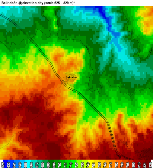
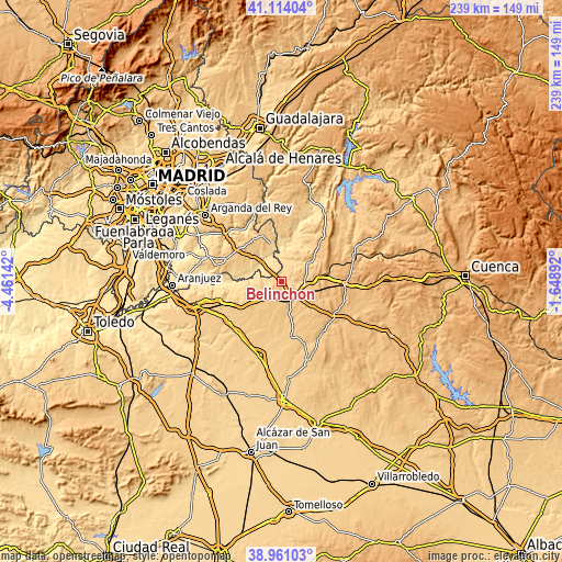
| \ | Map #1 | Topo.Map |
| Scale [m] | 625..829 m | × |
| Scale [ft] | 2051..2720 ft | × |
| Average | 739.4 m = 2426 ft | × |
| Width | 7.48 km = 4.6 mi | 239.4 km = 148.8 mi |
| Height | 7.48 km = 4.6 mi | 239.4 km = 148.8 mi |
| ↑Max Latitude | 40.079663° | 41.11404° |
| Latitude at center | 40.04603° | 40.04603° |
| ↓Min Latitude | 40.01238° | 38.96103° |
| ← Min Longitude | -3.099115° | -4.46142° |
| Longitude center | -3.05517° | -3.05517° |
| →Max Longitude | -3.011225° | -1.64892° |
Nearby cities:
Cities around Belinchón sort by population:
• Tarancón elevation 817 m
5.8 km,  135°
135°
• Santa Cruz de la Zarza 787 m
13.4 km,  237°
237°
• Fuentidueña de Tajo 552 m
11.6 km,  311°
311°
• Fuente de Pedro Naharro 774 m
14.1 km,  163°
163°
• Estremera 626 m
15.7 km,  345°
345°
• Barajas de Melo 716 m
14.6 km,  53°
53°
• Villamanrique de Tajo 533 m
15.6 km,  278°
278°
• Zarza de Tajo 720 m
7.1 km, 241°
• Leganiel 753 m
16 km,  33°
33°
• Tribaldos 830 m
15.7 km,  121°
121°
• Paredes 835 m
17.3 km,  82°
82°
• Huelves 822 m
14.5 km,  91°
91°
Multilingual:
 En español:
Belinchón elevación 716 m.
 En France:
Belinchón élévation 716 m.
 Auf Deutsch:
Belinchón höhe über dem Meeresspiegel ist 716 m.

Sources and notes:
- [note 1] Map square and city borders are not equal. Map elevation data is calculated only from area inside that square.
- [src 1] Elevation data from geonames database provided with same terms of usage.
- [src 2] The elevation map of Belinchón is generated using elevation data from NASA's 3 arcsec (90m) resolution SRTM data.
- [src 3] Base (background) map © OpenStreetMap contributors tiles are generated by Geofabrik and OpenTopoMap.
Copyright & License:
This Belinchón Elevation Map is licensed under CC BY-SA. You may reuse any part from this page, if you give a proper credit by linking to this URL:
 More info on terms of use page.