Liceras elevation
Liceras (Castille and León, Provincia de Soria), Spain elevation is 1127 meters and Liceras elevation in feet is 3698 ft above sea level [src 1]. Liceras is a seat of a third-order administrative division (feature code) with elevation that is 524 meters (1719 ft) bigger than average city elevation in Spain.
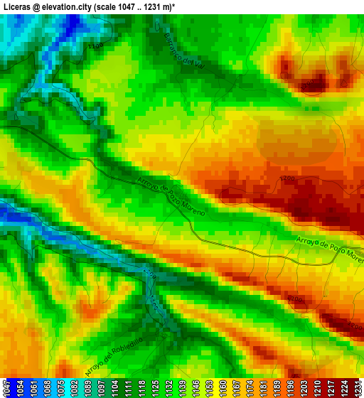
Below is the Elevation map of Liceras, which displays elevation range with different colors. Scale of the first map is from 1047 to 1231 m (3435 to 4039 ft) with average elevation of 1145.6 meters (=3759 ft) [note 1]
These maps also provides idea of topography and contour of this city, they are displayed at different zoom levels. More info about maps, scale and edge coordinates you can find below images.
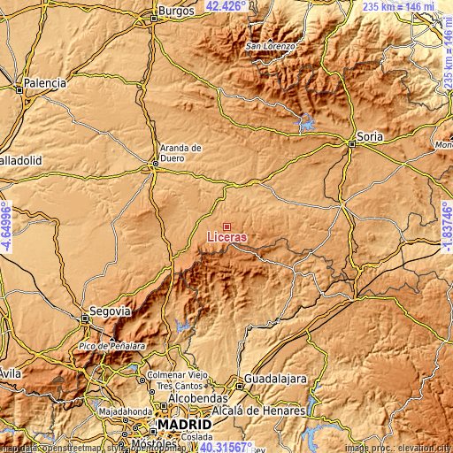
| \ | Map #1 | Topo.Map |
| Scale [m] | 1047..1231 m | × |
| Scale [ft] | 3435..4039 ft | × |
| Average | 1145.6 m = 3759 ft | × |
| Width | 7.33 km = 4.6 mi | 234.6 km = 145.8 mi |
| Height | 7.33 km = 4.6 mi | 234.6 km = 145.8 mi |
| ↑Max Latitude | 41.412356° | 42.426° |
| Latitude at center | 41.37939° | 41.37939° |
| ↓Min Latitude | 41.346407° | 40.31567° |
| ← Min Longitude | -3.287655° | -4.64996° |
| Longitude center | -3.24371° | -3.24371° |
| →Max Longitude | -3.199765° | -1.83746° |
Nearby cities:
Cities around Liceras sort by population:
• Ayllón elevation 986 m
11.8 km,  291°
291°
• Montejo de Tiermes 1151 m
3.8 km,  108°
108°
• Cantalojas 1316 m
16.1 km,  180°
180°
• Languilla 952 m
17 km,  297°
297°
• Corral de Ayllón 1028 m
18 km,  274°
274°
• Campisábalos 1359 m
15.6 km,  143°
143°
• Fuentecambrón 1015 m
15.7 km,  333°
333°
• Ribota 1032 m
15.6 km,  264°
264°
• Fresno de Caracena 951 m
15.1 km,  57°
57°
• Carrascosa de Abajo 1011 m
13.8 km,  69°
69°
• Villanueva de Gormaz 968 m
18 km, 57°
• Caracena 1081 m
12.7 km,  88°
88°
Multilingual:
 En español:
Liceras elevación 1127 m.
 En France:
Liceras élévation 1127 m.
 Auf Deutsch:
Liceras höhe über dem Meeresspiegel ist 1127 m.

Sources and notes:
- [note 1] Map square and city borders are not equal. Map elevation data is calculated only from area inside that square.
- [src 1] Elevation data from geonames database provided with same terms of usage.
- [src 2] The elevation map of Liceras is generated using elevation data from NASA's 3 arcsec (90m) resolution SRTM data.
- [src 3] Base (background) map © OpenStreetMap contributors tiles are generated by Geofabrik and OpenTopoMap.
Copyright & License:
This Liceras Elevation Map is licensed under CC BY-SA. You may reuse any part from this page, if you give a proper credit by linking to this URL:
 More info on terms of use page.