Cantalojas elevation
Cantalojas (Castille-La Mancha, Provincia de Guadalajara), Spain elevation is 1316 meters and Cantalojas elevation in feet is 4318 ft above sea level [src 1]. Cantalojas is a seat of a third-order administrative division (feature code) with elevation that is 713 meters (2339 ft) bigger than average city elevation in Spain.
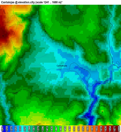
Below is the Elevation map of Cantalojas, which displays elevation range with different colors. Scale of the first map is from 1241 to 1688 m (4072 to 5538 ft) with average elevation of 1393 meters (=4570 ft) [note 1]
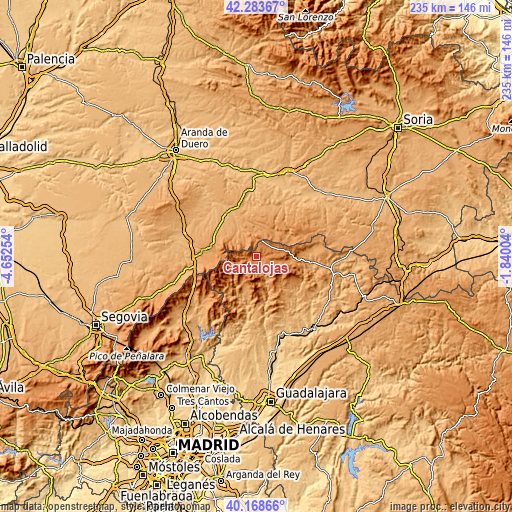
These maps also provides idea of topography and contour of this city, they are displayed at different zoom levels. More info about maps, scale and edge coordinates you can find below images.
| \ | Map #1 | Topo.Map |
| Scale [m] | 1241..1688 m | × |
| Scale [ft] | 4072..5538 ft | × |
| Average | 1393 m = 4570 ft | × |
| Width | 7.35 km = 4.6 mi | 235.2 km = 146.1 mi |
| Height | 7.35 km = 4.6 mi | 235.2 km = 146.1 mi |
| ↑Max Latitude | 41.267759° | 42.28367° |
| Latitude at center | 41.23472° | 41.23472° |
| ↓Min Latitude | 41.201664° | 40.16866° |
| ← Min Longitude | -3.290235° | -4.65254° |
| Longitude center | -3.24629° | -3.24629° |
| →Max Longitude | -3.202345° | -1.84004° |
Nearby cities:
Cities around Cantalojas sort by population:
• Montejo de Tiermes elevation 1151 m
15.4 km,  14°
14°
• Campillo de Ranas 1100 m
17.5 km,  199°
199°
• Condemios de Arriba 1305 m
10.3 km,  101°
101°
• Galve de Sorbe 1392 m
5.6 km,  110°
110°
• Valverde de los Arroyos 1257 m
11.8 km,  174°
174°
• Majaelrayo 1187 m
14.4 km, 199°
• Campisábalos 1359 m
10.1 km,  69°
69°
• Liceras 1127 m
16.1 km,  0°
0°
• Arroyo de las Fraguas 1215 m
17.6 km,  146°
146°
• Albendiego 1188 m
16.3 km,  92°
92°
• Somolinos 1245 m
15.6 km, 85°
• Condemios de Abajo 1290 m
12.4 km, 99°
Multilingual:
 En español:
Cantalojas elevación 1316 m.
 En France:
Cantalojas élévation 1316 m.
 Auf Deutsch:
Cantalojas höhe über dem Meeresspiegel ist 1316 m.

Sources and notes:
- [note 1] Map square and city borders are not equal. Map elevation data is calculated only from area inside that square.
- [src 1] Elevation data from geonames database provided with same terms of usage.
- [src 2] The elevation map of Cantalojas is generated using elevation data from NASA's 3 arcsec (90m) resolution SRTM data.
- [src 3] Base (background) map © OpenStreetMap contributors tiles are generated by Geofabrik and OpenTopoMap.
Copyright & License:
This Cantalojas Elevation Map is licensed under CC BY-SA. You may reuse any part from this page, if you give a proper credit by linking to this URL:
 More info on terms of use page.