Manzaneda elevation
Manzaneda (Galicia, Provincia de Ourense), Spain elevation is 661 meters and Manzaneda elevation in feet is 2169 ft above sea level [src 1]. Manzaneda is a seat of a third-order administrative division (feature code) with elevation that is 58 meters (190 ft) bigger than average city elevation in Spain.
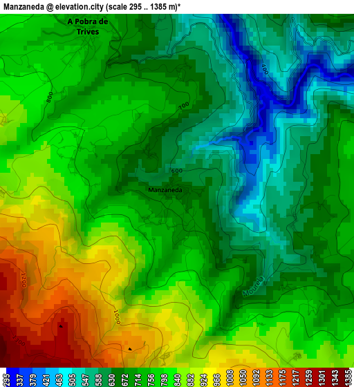
Below is the Elevation map of Manzaneda, which displays elevation range with different colors. Scale of the first map is from 295 to 1385 m (968 to 4544 ft) with average elevation of 748.8 meters (=2457 ft) [note 1]
These maps also provides idea of topography and contour of this city, they are displayed at different zoom levels. More info about maps, scale and edge coordinates you can find below images.
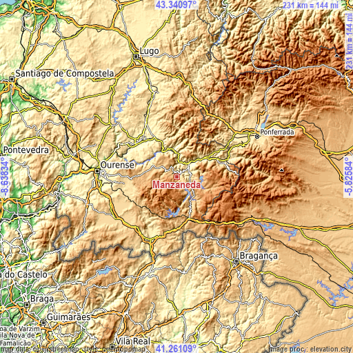
| \ | Map #1 | Topo.Map |
| Scale [m] | 295..1385 m | × |
| Scale [ft] | 968..4544 ft | × |
| Average | 748.8 m = 2457 ft | × |
| Width | 7.23 km = 4.5 mi | 231.3 km = 143.7 mi |
| Height | 7.23 km = 4.5 mi | 231.3 km = 143.7 mi |
| ↑Max Latitude | 42.34211° | 43.34097° |
| Latitude at center | 42.30962° | 42.30962° |
| ↓Min Latitude | 42.277113° | 41.26109° |
| ← Min Longitude | -7.276035° | -8.63834° |
| Longitude center | -7.23209° | -7.23209° |
| →Max Longitude | -7.188145° | -5.82584° |
Nearby cities:
Cities around Manzaneda sort by population:
• O Barco de Valdeorras elevation 323 m
23.2 km,  59°
59°
• A Rúa 335 m
14.7 km,  46°
46°
• Quiroga 286 m
18.9 km,  349°
349°
• Lobios 532 m
26.9 km,  293°
293°
• A Pobra do Brollon 387 m
30.4 km,  334°
334°
• Pobra de Trives 746 m
3.7 km, 332°
• Castro Caldelas 749 m
17.4 km, 294°
• Petín 319 m
11.7 km, 46°
• Montederramo 906 m
22.5 km,  260°
260°
• Pías 1100 m
31.6 km,  142°
142°
• Porto 1206 m
31.6 km,  120°
120°
• Vilariño de Conso 764 m
16.4 km,  165°
165°
Multilingual:
 En español:
Manzaneda elevación 661 m.
 En France:
Manzaneda élévation 661 m.
 Auf Deutsch:
Manzaneda höhe über dem Meeresspiegel ist 661 m.

Sources and notes:
- [note 1] Map square and city borders are not equal. Map elevation data is calculated only from area inside that square.
- [src 1] Elevation data from geonames database provided with same terms of usage.
- [src 2] The elevation map of Manzaneda is generated using elevation data from NASA's 3 arcsec (90m) resolution SRTM data.
- [src 3] Base (background) map © OpenStreetMap contributors tiles are generated by Geofabrik and OpenTopoMap.
Copyright & License:
This Manzaneda Elevation Map is licensed under CC BY-SA. You may reuse any part from this page, if you give a proper credit by linking to this URL:
 More info on terms of use page.