A Rúa elevation
A Rúa (Galicia, Provincia de Ourense), Spain elevation is 335 meters and A Rúa elevation in feet is 1099 ft above sea level [src 1]. A Rúa is a populated place (feature code) with elevation that is 268 meters (879 ft) smaller than average city elevation in Spain.
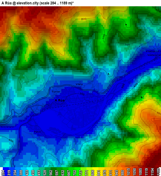
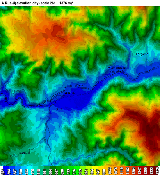
Below is the Elevation map of A Rúa, which displays elevation range with different colors. Scale of the first map is from 284 to 1189 m (932 to 3901 ft) with average elevation of 564.5 meters (=1852 ft) [note 1]
These maps also provides idea of topography and contour of this city, they are displayed at different zoom levels. More info about maps, scale and edge coordinates you can find below images.
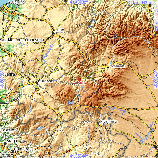
| \ | Map #1 | Map #2 | Topo.Map |
| Scale [m] | 284..1189 m | 261..1376 m | × |
| Scale [ft] | 932..3901 ft | 856..4514 ft | × |
| Average | 564.5 m = 1852 ft | 692 m = 2270 ft | × |
| Width | 7.22 km = 4.5 mi | 14.43 km = 9 mi | 230.9 km = 143.5 mi |
| Height | 7.22 km = 4.5 mi | 14.43 km = 9 mi | 230.9 km = 143.5 mi |
| ↑Max Latitude | 42.432923° | 42.465349° | 43.43032° |
| Latitude at center | 42.40048° | 42.40048° | 42.40048° |
| ↓Min Latitude | 42.36802° | 42.335544° | 41.35345° |
| ← Min Longitude | -7.146625° | -7.190571° | -8.50893° |
| Longitude center | -7.10268° | -7.10268° | -7.10268° |
| →Max Longitude | -7.058735° | -7.014789° | -5.69643° |
Nearby cities:
Cities around A Rúa sort by population:
• O Barco de Valdeorras elevation 323 m
9.4 km,  79°
79°
• Quiroga 286 m
16.5 km,  301°
301°
• A Pobra do Brollon 387 m
29.3 km,  306°
306°
• Pobra de Trives 746 m
14.1 km,  241°
241°
• Puente de Domingo Flórez 369 m
23.2 km,  86°
86°
• Castro Caldelas 749 m
26.7 km,  263°
263°
• Manzaneda 661 m
14.7 km,  226°
226°
• Petín 319 m
3 km, 226°
• Oencia 868 m
19.7 km,  33°
33°
• Barjas 845 m
25.6 km,  23°
23°
• Vilariño de Conso 764 m
26.8 km,  194°
194°
• Sobrado 416 m
24.4 km,  58°
58°
Multilingual:
 En español:
A Rúa elevación 335 m.
 En France:
A Rúa élévation 335 m.


Sources and notes:
- [note 1] Map square and city borders are not equal. Map elevation data is calculated only from area inside that square.
- [src 1] Elevation data from geonames database provided with same terms of usage.
- [src 2] The elevation map of A Rúa is generated using elevation data from NASA's 3 arcsec (90m) resolution SRTM data.
- [src 3] Base (background) map © OpenStreetMap contributors tiles are generated by Geofabrik and OpenTopoMap.
Copyright & License:
This A Rúa Elevation Map is licensed under CC BY-SA. You may reuse any part from this page, if you give a proper credit by linking to this URL:
 More info on terms of use page.