Porto elevation
Porto (Castille and León, Provincia de Zamora), Spain elevation is 1206 meters and Porto elevation in feet is 3957 ft above sea level [src 1]. Porto is a seat of a third-order administrative division (feature code) with elevation that is 603 meters (1978 ft) bigger than average city elevation in Spain.
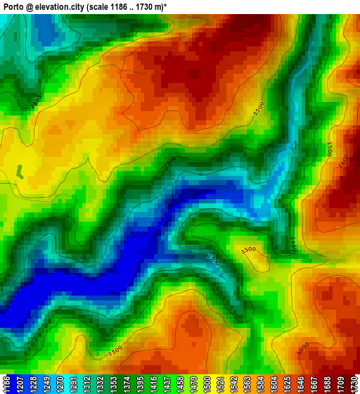
Below is the Elevation map of Porto, which displays elevation range with different colors. Scale of the first map is from 1186 to 1730 m (3891 to 5676 ft) with average elevation of 1456.3 meters (=4778 ft) [note 1]
These maps also provides idea of topography and contour of this city, they are displayed at different zoom levels. More info about maps, scale and edge coordinates you can find below images.
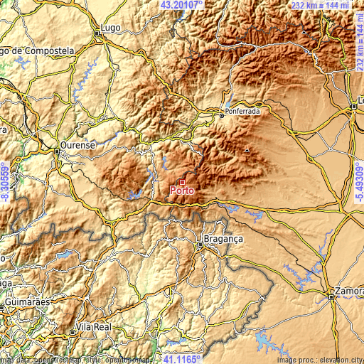
| \ | Map #1 | Topo.Map |
| Scale [m] | 1186..1730 m | × |
| Scale [ft] | 3891..5676 ft | × |
| Average | 1456.3 m = 4778 ft | × |
| Width | 7.24 km = 4.5 mi | 231.8 km = 144 mi |
| Height | 7.24 km = 4.5 mi | 231.8 km = 144 mi |
| ↑Max Latitude | 42.199933° | 43.20107° |
| Latitude at center | 42.16737° | 42.16737° |
| ↓Min Latitude | 42.13479° | 41.1165° |
| ← Min Longitude | -6.943285° | -8.30559° |
| Longitude center | -6.89934° | -6.89934° |
| →Max Longitude | -6.855395° | -5.49309° |
Nearby cities:
Cities around Porto sort by population:
• Puebla de Sanabria elevation 933 m
25.3 km,  119°
119°
• Galende 964 m
20.7 km,  109°
109°
• Encinedo 976 m
27.7 km,  65°
65°
• Cobreros 994 m
19.5 km, 122°
• Robleda-Cervantes 1019 m
26.9 km, 110°
• Lubián 1034 m
14.7 km,  181°
181°
• Hermisende 842 m
22.1 km, 179°
• San Justo 1061 m
23 km,  99°
99°
• Trefacio 975 m
20.8 km, 104°
• Vilariño de Conso 764 m
23.4 km,  269°
269°
• Requejo 993 m
20 km,  139°
139°
• Pías 1100 m
12.5 km,  221°
221°
Multilingual:
 En español:
Porto elevación 1206 m.
 En France:
Porto élévation 1206 m.


Sources and notes:
- [note 1] Map square and city borders are not equal. Map elevation data is calculated only from area inside that square.
- [src 1] Elevation data from geonames database provided with same terms of usage.
- [src 2] The elevation map of Porto is generated using elevation data from NASA's 3 arcsec (90m) resolution SRTM data.
- [src 3] Base (background) map © OpenStreetMap contributors tiles are generated by Geofabrik and OpenTopoMap.
Copyright & License:
This Porto Elevation Map is licensed under CC BY-SA. You may reuse any part from this page, if you give a proper credit by linking to this URL:
 More info on terms of use page.