Martínez elevation
Martínez (Castille and León, Provincia de Ávila), Spain elevation is 1100 meters and Martínez elevation in feet is 3609 ft above sea level [src 1]. Martínez is a seat of a third-order administrative division (feature code) with elevation that is 497 meters (1631 ft) bigger than average city elevation in Spain.
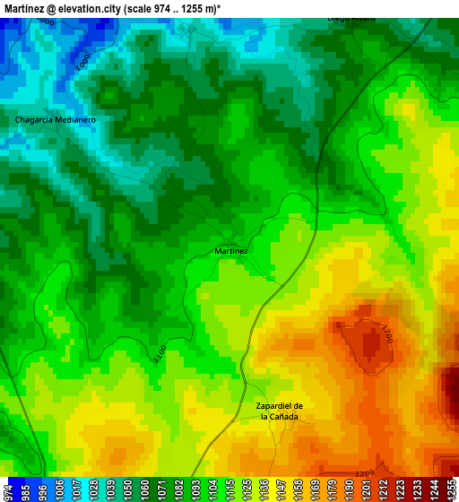
Below is the Elevation map of Martínez, which displays elevation range with different colors. Scale of the first map is from 974 to 1255 m (3196 to 4117 ft) with average elevation of 1102.6 meters (=3617 ft) [note 1]
These maps also provides idea of topography and contour of this city, they are displayed at different zoom levels. More info about maps, scale and edge coordinates you can find below images.
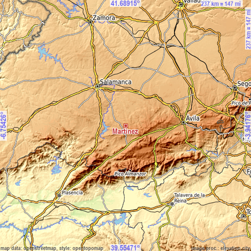
| \ | Map #1 | Topo.Map |
| Scale [m] | 974..1255 m | × |
| Scale [ft] | 3196..4117 ft | × |
| Average | 1102.6 m = 3617 ft | × |
| Width | 7.42 km = 4.6 mi | 237.3 km = 147.5 mi |
| Height | 7.42 km = 4.6 mi | 237.3 km = 147.5 mi |
| ↑Max Latitude | 40.663803° | 41.68915° |
| Latitude at center | 40.63046° | 40.63046° |
| ↓Min Latitude | 40.5971° | 39.55471° |
| ← Min Longitude | -5.391955° | -6.75426° |
| Longitude center | -5.34801° | -5.34801° |
| →Max Longitude | -5.304065° | -3.94176° |
Nearby cities:
Cities around Martínez sort by population:
• Alaraz elevation 884 m
14.1 km,  21°
21°
• Armenteros 1056 m
9.4 km,  243°
243°
• Pedraza de Alba 898 m
14 km,  350°
350°
• Malpartida de Corneja 1025 m
12.1 km,  180°
180°
• San Miguel de Serrezuela 1098 m
6.7 km,  48°
48°
• Bonilla de la Sierra 1080 m
13.1 km,  147°
147°
• Zapardiel de la Cañada 1151 m
2.8 km,  162°
162°
• Becedillas 1069 m
10.4 km,  169°
169°
• Narrillos del Álamo 1125 m
12.2 km,  234°
234°
• Tórtoles 1240 m
10.6 km,  136°
136°
• Collado del Mirón 1168 m
8.6 km, 183°
• Pascualcobo 1072 m
6.6 km,  64°
64°
Multilingual:
 En español:
Martínez elevación 1100 m.
 En France:
Martínez élévation 1100 m.
 Auf Deutsch:
Martínez höhe über dem Meeresspiegel ist 1100 m.

Sources and notes:
- [note 1] Map square and city borders are not equal. Map elevation data is calculated only from area inside that square.
- [src 1] Elevation data from geonames database provided with same terms of usage.
- [src 2] The elevation map of Martínez is generated using elevation data from NASA's 3 arcsec (90m) resolution SRTM data.
- [src 3] Base (background) map © OpenStreetMap contributors tiles are generated by Geofabrik and OpenTopoMap.
Copyright & License:
This Martínez Elevation Map is licensed under CC BY-SA. You may reuse any part from this page, if you give a proper credit by linking to this URL:
 More info on terms of use page.