Megina elevation
Megina (Castille-La Mancha, Provincia de Guadalajara), Spain elevation is 1253 meters and Megina elevation in feet is 4111 ft above sea level [src 1]. Megina is a seat of a third-order administrative division (feature code) with elevation that is 650 meters (2133 ft) bigger than average city elevation in Spain.
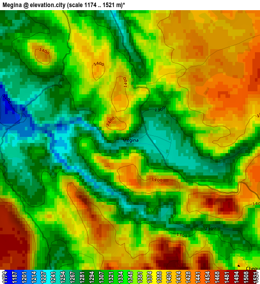
Below is the Elevation map of Megina, which displays elevation range with different colors. Scale of the first map is from 1174 to 1521 m (3852 to 4990 ft) with average elevation of 1348.9 meters (=4426 ft) [note 1]
These maps also provides idea of topography and contour of this city, they are displayed at different zoom levels. More info about maps, scale and edge coordinates you can find below images.
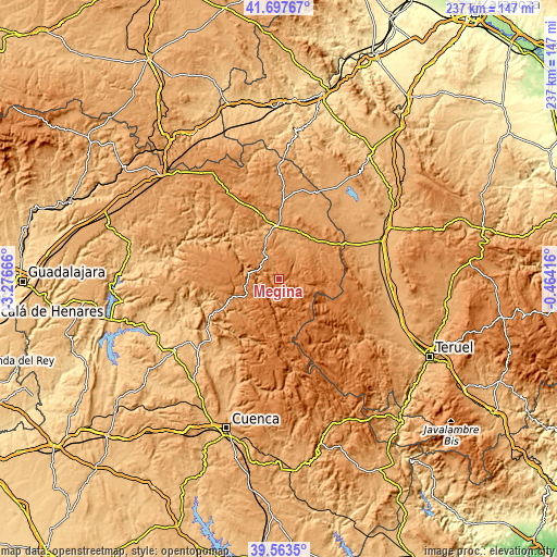
| \ | Map #1 | Topo.Map |
| Scale [m] | 1174..1521 m | × |
| Scale [ft] | 3852..4990 ft | × |
| Average | 1348.9 m = 4426 ft | × |
| Width | 7.42 km = 4.6 mi | 237.3 km = 147.5 mi |
| Height | 7.42 km = 4.6 mi | 237.3 km = 147.5 mi |
| ↑Max Latitude | 40.672449° | 41.69767° |
| Latitude at center | 40.63911° | 40.63911° |
| ↓Min Latitude | 40.605755° | 39.5635° |
| ← Min Longitude | -1.914355° | -3.27666° |
| Longitude center | -1.87041° | -1.87041° |
| →Max Longitude | -1.826465° | -0.46416° |
Nearby cities:
Cities around Megina sort by population:
• Checa elevation 1374 m
9 km,  131°
131°
• Poveda de la Sierra 1191 m
13.4 km,  271°
271°
• Alcoroches 1410 m
10.6 km,  97°
97°
• Peralejos de las Truchas 1190 m
6.1 km,  212°
212°
• Piqueras 1373 m
12.8 km,  77°
77°
• Taravilla 1320 m
10.5 km,  308°
308°
• Tierzo 1145 m
13.3 km,  337°
337°
• Baños de Tajo 1287 m
11.8 km,  316°
316°
• Terzaga 1183 m
6.8 km, 335°
• Pinilla de Molina 1220 m
4.6 km,  349°
349°
• Torrecuadrada de Molina 1189 m
13.4 km,  23°
23°
• Chequilla 1359 m
5.1 km,  135°
135°
Multilingual:
 En español:
Megina elevación 1253 m.
 En France:
Megina élévation 1253 m.


Sources and notes:
- [note 1] Map square and city borders are not equal. Map elevation data is calculated only from area inside that square.
- [src 1] Elevation data from geonames database provided with same terms of usage.
- [src 2] The elevation map of Megina is generated using elevation data from NASA's 3 arcsec (90m) resolution SRTM data.
- [src 3] Base (background) map © OpenStreetMap contributors tiles are generated by Geofabrik and OpenTopoMap.
Copyright & License:
This Megina Elevation Map is licensed under CC BY-SA. You may reuse any part from this page, if you give a proper credit by linking to this URL:
 More info on terms of use page.