Checa elevation
Checa (Castille-La Mancha, Provincia de Guadalajara), Spain elevation is 1374 meters and Checa elevation in feet is 4508 ft above sea level [src 1]. Checa is a seat of a third-order administrative division (feature code) with elevation that is 771 meters (2530 ft) bigger than average city elevation in Spain.
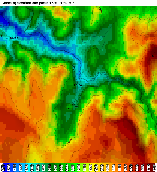
Below is the Elevation map of Checa, which displays elevation range with different colors. Scale of the first map is from 1279 to 1717 m (4196 to 5633 ft) with average elevation of 1518.5 meters (=4982 ft) [note 1]
These maps also provides idea of topography and contour of this city, they are displayed at different zoom levels. More info about maps, scale and edge coordinates you can find below images.
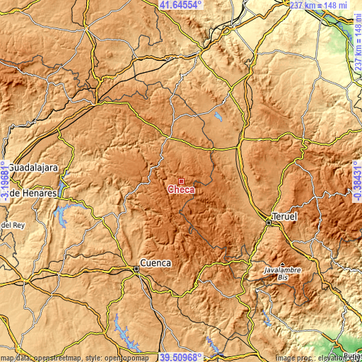
| \ | Map #1 | Topo.Map |
| Scale [m] | 1279..1717 m | × |
| Scale [ft] | 4196..5633 ft | × |
| Average | 1518.5 m = 4982 ft | × |
| Width | 7.42 km = 4.6 mi | 237.5 km = 147.6 mi |
| Height | 7.42 km = 4.6 mi | 237.5 km = 147.6 mi |
| ↑Max Latitude | 40.619505° | 41.64554° |
| Latitude at center | 40.58614° | 40.58614° |
| ↓Min Latitude | 40.552758° | 39.50968° |
| ← Min Longitude | -1.834505° | -3.19681° |
| Longitude center | -1.79056° | -1.79056° |
| →Max Longitude | -1.746615° | -0.38431° |
Nearby cities:
Cities around Checa sort by population:
• Orihuela del Tremedal elevation 1439 m
12.5 km,  108°
108°
• Alustante 1404 m
11.5 km,  74°
74°
• Orea 1502 m
6.2 km,  121°
121°
• Peralejos de las Truchas 1190 m
10.1 km,  274°
274°
• Alcoroches 1410 m
5.9 km,  39°
39°
• Adobes 1383 m
13.7 km, 43°
• Piqueras 1373 m
10.4 km,  33°
33°
• Megina 1253 m
9 km,  311°
311°
• Terzaga 1183 m
15.4 km,  321°
321°
• Pinilla de Molina 1220 m
12.9 km, 323°
• Anquela del Pedregal 1283 m
18.1 km,  14°
14°
• Chequilla 1359 m
3.8 km, 305°
Multilingual:
 En español:
Checa elevación 1374 m.
 En France:
Checa élévation 1374 m.


Sources and notes:
- [note 1] Map square and city borders are not equal. Map elevation data is calculated only from area inside that square.
- [src 1] Elevation data from geonames database provided with same terms of usage.
- [src 2] The elevation map of Checa is generated using elevation data from NASA's 3 arcsec (90m) resolution SRTM data.
- [src 3] Base (background) map © OpenStreetMap contributors tiles are generated by Geofabrik and OpenTopoMap.
Copyright & License:
This Checa Elevation Map is licensed under CC BY-SA. You may reuse any part from this page, if you give a proper credit by linking to this URL:
 More info on terms of use page.