Monegrillo elevation
Monegrillo (Aragon, Provincia de Zaragoza), Spain elevation is 433 meters and Monegrillo elevation in feet is 1421 ft above sea level [src 1]. Monegrillo is a seat of a third-order administrative division (feature code) with elevation that is 170 meters (558 ft) smaller than average city elevation in Spain.
Below is the Elevation map of Monegrillo, which displays elevation range with different colors. Scale of the first map is from 344 to 707 m (1129 to 2320 ft) with average elevation of 435.6 meters (=1429 ft) [note 1]
These maps also provides idea of topography and contour of this city, they are displayed at different zoom levels. More info about maps, scale and edge coordinates you can find below images.
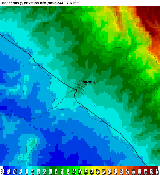
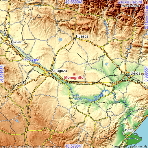
| \ | Map #1 | Topo.Map |
| Scale [m] | 344..707 m | × |
| Scale [ft] | 1129..2320 ft | × |
| Average | 435.6 m = 1429 ft | × |
| Width | 7.3 km = 4.5 mi | 233.7 km = 145.2 mi |
| Height | 7.3 km = 4.5 mi | 233.7 km = 145.2 mi |
| ↑Max Latitude | 41.671394° | 42.68094° |
| Latitude at center | 41.63856° | 41.63856° |
| ↓Min Latitude | 41.605709° | 40.57904° |
| ← Min Longitude | -0.459645° | -1.82195° |
| Longitude center | -0.4157° | -0.4157° |
| →Max Longitude | -0.371755° | 0.99055° |
Nearby cities:
Cities around Monegrillo sort by population:
• Fuentes de Ebro elevation 198 m
22.8 km,  232°
232°
• Pina de Ebro 159 m
19.3 km,  209°
209°
• Alfajarín 191 m
24.1 km,  263°
263°
• Lanaja 369 m
16.3 km,  25°
25°
• Leciñena 417 m
24.1 km,  317°
317°
• Villafranca de Ebro 176 m
20.8 km,  250°
250°
• Castejón de Monegros 477 m
14.8 km,  98°
98°
• Nuez de Ebro 182 m
21.6 km, 255°
• Perdiguera 467 m
22.1 km,  305°
305°
• Farlete 410 m
8.9 km,  302°
302°
• Alcubierre 456 m
19 km,  350°
350°
• Albalatillo 261 m
24.5 km,  63°
63°
Multilingual:
 En español:
Monegrillo elevación 433 m.
 En France:
Monegrillo élévation 433 m.
 Auf Deutsch:
Monegrillo höhe über dem Meeresspiegel ist 433 m.

Sources and notes:
- [note 1] Map square and city borders are not equal. Map elevation data is calculated only from area inside that square.
- [src 1] Elevation data from geonames database provided with same terms of usage.
- [src 2] The elevation map of Monegrillo is generated using elevation data from NASA's 3 arcsec (90m) resolution SRTM data.
- [src 3] Base (background) map © OpenStreetMap contributors tiles are generated by Geofabrik and OpenTopoMap.
Copyright & License:
This Monegrillo Elevation Map is licensed under CC BY-SA. You may reuse any part from this page, if you give a proper credit by linking to this URL:
 More info on terms of use page.