Leciñena elevation
Leciñena (Aragon, Provincia de Zaragoza), Spain elevation is 417 meters and Leciñena elevation in feet is 1368 ft above sea level [src 1]. Leciñena is a seat of a third-order administrative division (feature code) with elevation that is 186 meters (610 ft) smaller than average city elevation in Spain.
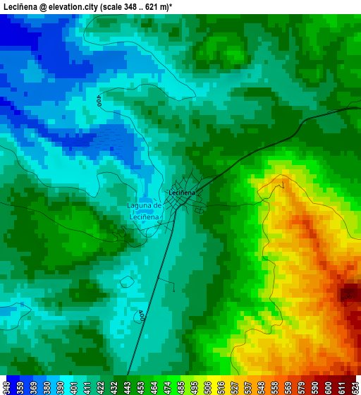
Below is the Elevation map of Leciñena, which displays elevation range with different colors. Scale of the first map is from 348 to 621 m (1142 to 2037 ft) with average elevation of 437 meters (=1434 ft) [note 1]
These maps also provides idea of topography and contour of this city, they are displayed at different zoom levels. More info about maps, scale and edge coordinates you can find below images.
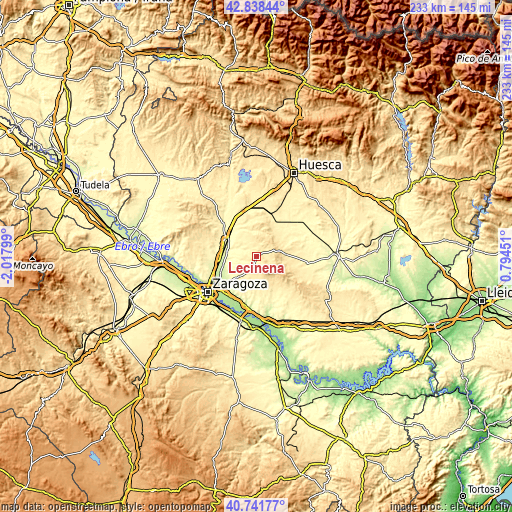
| \ | Map #1 | Topo.Map |
| Scale [m] | 348..621 m | × |
| Scale [ft] | 1142..2037 ft | × |
| Average | 437 m = 1434 ft | × |
| Width | 7.29 km = 4.5 mi | 233.1 km = 144.8 mi |
| Height | 7.29 km = 4.5 mi | 233.1 km = 144.8 mi |
| ↑Max Latitude | 41.831432° | 42.83844° |
| Latitude at center | 41.79868° | 41.79868° |
| ↓Min Latitude | 41.765911° | 40.74177° |
| ← Min Longitude | -0.655685° | -2.01799° |
| Longitude center | -0.61174° | -0.61174° |
| →Max Longitude | -0.567795° | 0.79451° |
Nearby cities:
Cities around Leciñena sort by population:
• Zuera elevation 283 m
16.6 km,  297°
297°
• Villanueva de Gállego 252 m
17.9 km,  259°
259°
• Villamayor de Gállego 240 m
18.3 km,  226°
226°
• San Mateo de Gállego 286 m
13.2 km,  285°
285°
• Alfajarín 191 m
21.9 km,  200°
200°
• Tardienta 386 m
20.8 km,  17°
17°
• Robres 396 m
14.6 km,  58°
58°
• Perdiguera 467 m
5.2 km, 198°
• Farlete 410 m
15.7 km,  146°
146°
• Alcubierre 456 m
13.2 km,  85°
85°
• Torralba de Aragón 395 m
17.3 km,  28°
28°
• Senés de Alcubierre 390 m
15.8 km,  40°
40°
Multilingual:
 En español:
Leciñena elevación 417 m.
 En France:
Leciñena élévation 417 m.
 Auf Deutsch:
Leciñena höhe über dem Meeresspiegel ist 417 m.

Sources and notes:
- [note 1] Map square and city borders are not equal. Map elevation data is calculated only from area inside that square.
- [src 1] Elevation data from geonames database provided with same terms of usage.
- [src 2] The elevation map of Leciñena is generated using elevation data from NASA's 3 arcsec (90m) resolution SRTM data.
- [src 3] Base (background) map © OpenStreetMap contributors tiles are generated by Geofabrik and OpenTopoMap.
Copyright & License:
This Leciñena Elevation Map is licensed under CC BY-SA. You may reuse any part from this page, if you give a proper credit by linking to this URL:
 More info on terms of use page.