Albalatillo elevation
Albalatillo (Aragon, Provincia de Huesca), Spain elevation is 261 meters and Albalatillo elevation in feet is 856 ft above sea level [src 1]. Albalatillo is a seat of a third-order administrative division (feature code) with elevation that is 342 meters (1122 ft) smaller than average city elevation in Spain.
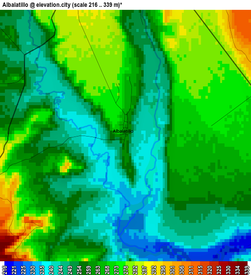
Below is the Elevation map of Albalatillo, which displays elevation range with different colors. Scale of the first map is from 216 to 339 m (709 to 1112 ft) with average elevation of 260.6 meters (=855 ft) [note 1]
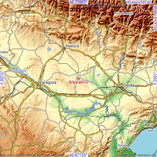
These maps also provides idea of topography and contour of this city, they are displayed at different zoom levels. More info about maps, scale and edge coordinates you can find below images.
| \ | Map #1 | Topo.Map |
| Scale [m] | 216..339 m | × |
| Scale [ft] | 709..1112 ft | × |
| Average | 260.6 m = 855 ft | × |
| Width | 7.29 km = 4.5 mi | 233.4 km = 145 mi |
| Height | 7.29 km = 4.5 mi | 233.4 km = 145 mi |
| ↑Max Latitude | 41.768055° | 42.77607° |
| Latitude at center | 41.73527° | 41.73527° |
| ↓Min Latitude | 41.702468° | 40.67733° |
| ← Min Longitude | -0.195095° | -1.5574° |
| Longitude center | -0.15115° | -0.15115° |
| →Max Longitude | -0.107205° | 1.2551° |
Nearby cities:
Cities around Albalatillo sort by population:
• Sariñena elevation 293 m
6.3 km,  354°
354°
• Lanaja 369 m
15.4 km,  284°
284°
• Castejón de Monegros 477 m
15 km,  209°
209°
• Ontiñena 215 m
20.9 km,  108°
108°
• Villanueva de Sigena 235 m
12 km,  100°
100°
• Alberuela de Tubo 352 m
20 km,  344°
344°
• Huerto 374 m
21.8 km,  356°
356°
• Poleñino 300 m
19.9 km,  318°
318°
• Capdesaso 312 m
12.3 km, 347°
• Castelflorite 311 m
13.1 km,  55°
55°
• Valfarta 369 m
19.8 km,  175°
175°
• Lalueza 286 m
14.4 km, 323°
Multilingual:
 En español:
Albalatillo elevación 261 m.
 En France:
Albalatillo élévation 261 m.
 Auf Deutsch:
Albalatillo höhe über dem Meeresspiegel ist 261 m.

Sources and notes:
- [note 1] Map square and city borders are not equal. Map elevation data is calculated only from area inside that square.
- [src 1] Elevation data from geonames database provided with same terms of usage.
- [src 2] The elevation map of Albalatillo is generated using elevation data from NASA's 3 arcsec (90m) resolution SRTM data.
- [src 3] Base (background) map © OpenStreetMap contributors tiles are generated by Geofabrik and OpenTopoMap.
Copyright & License:
This Albalatillo Elevation Map is licensed under CC BY-SA. You may reuse any part from this page, if you give a proper credit by linking to this URL:
 More info on terms of use page.