Navasfrías elevation
Navasfrías (Castille and León, Provincia de Salamanca), Spain elevation is 905 meters and Navasfrías elevation in feet is 2969 ft above sea level [src 1]. Navasfrías is a seat of a third-order administrative division (feature code) with elevation that is 302 meters (991 ft) bigger than average city elevation in Spain.
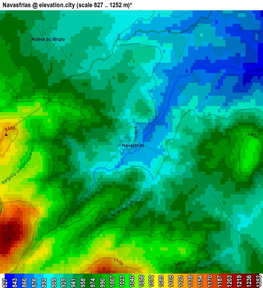
Below is the Elevation map of Navasfrías, which displays elevation range with different colors. Scale of the first map is from 827 to 1252 m (2713 to 4108 ft) with average elevation of 958.9 meters (=3146 ft) [note 1]
These maps also provides idea of topography and contour of this city, they are displayed at different zoom levels. More info about maps, scale and edge coordinates you can find below images.
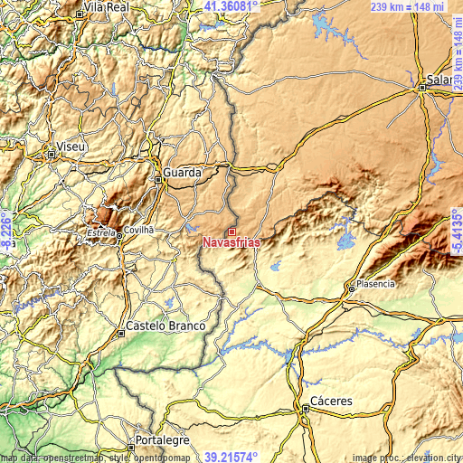
| \ | Map #1 | Topo.Map |
| Scale [m] | 827..1252 m | × |
| Scale [ft] | 2713..4108 ft | × |
| Average | 958.9 m = 3146 ft | × |
| Width | 7.45 km = 4.6 mi | 238.5 km = 148.2 mi |
| Height | 7.45 km = 4.6 mi | 238.5 km = 148.2 mi |
| ↑Max Latitude | 40.330299° | 41.36081° |
| Latitude at center | 40.29679° | 40.29679° |
| ↓Min Latitude | 40.263264° | 39.21574° |
| ← Min Longitude | -6.863695° | -8.226° |
| Longitude center | -6.81975° | -6.81975° |
| →Max Longitude | -6.775805° | -5.4135° |
Nearby cities:
Cities around Navasfrías sort by population:
• Valverde del Fresno elevation 479 m
9.7 km,  210°
210°
• Eljas 606 m
9.2 km,  194°
194°
• Perales del Puerto 429 m
19.5 km,  143°
143°
• San Martín de Trevejo 619 m
9.6 km,  167°
167°
• Hoyos 519 m
16.3 km,  148°
148°
• Fuenteguinaldo 853 m
19.1 km,  39°
39°
• Acebo 506 m
13.8 km, 140°
• Villamiel 758 m
12.6 km, 166°
• Peñaparda 866 m
13 km,  78°
78°
• Villasrubias 856 m
16 km,  73°
73°
• Puebla de Azaba 672 m
17.9 km,  20°
20°
• Casillas de Flores 860 m
10.8 km,  29°
29°
Multilingual:
 En español:
Navasfrías elevación 905 m.
 En France:
Navasfrías élévation 905 m.
 Auf Deutsch:
Navasfrías höhe über dem Meeresspiegel ist 905 m.

Sources and notes:
- [note 1] Map square and city borders are not equal. Map elevation data is calculated only from area inside that square.
- [src 1] Elevation data from geonames database provided with same terms of usage.
- [src 2] The elevation map of Navasfrías is generated using elevation data from NASA's 3 arcsec (90m) resolution SRTM data.
- [src 3] Base (background) map © OpenStreetMap contributors tiles are generated by Geofabrik and OpenTopoMap.
Copyright & License:
This Navasfrías Elevation Map is licensed under CC BY-SA. You may reuse any part from this page, if you give a proper credit by linking to this URL:
 More info on terms of use page.