Hoyos elevation
Hoyos (Extremadura, Provincia de Cáceres), Spain elevation is 519 meters and Hoyos elevation in feet is 1703 ft above sea level [src 1]. Hoyos is a seat of a third-order administrative division (feature code) with elevation that is 84 meters (276 ft) smaller than average city elevation in Spain.
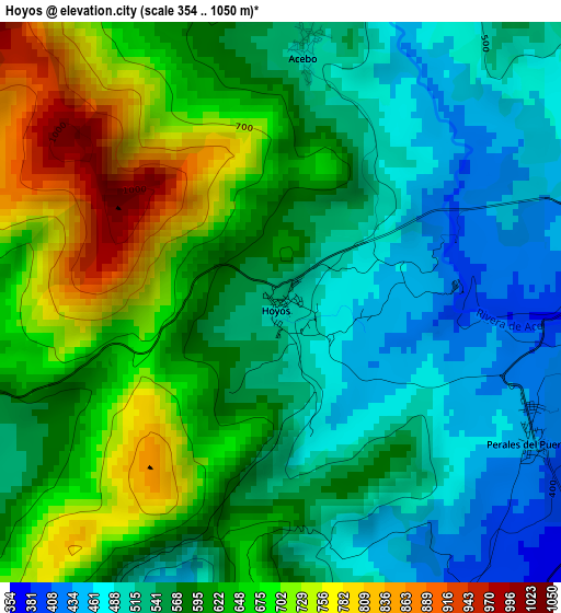
Below is the Elevation map of Hoyos, which displays elevation range with different colors. Scale of the first map is from 354 to 1050 m (1161 to 3445 ft) with average elevation of 592.4 meters (=1944 ft) [note 1]
These maps also provides idea of topography and contour of this city, they are displayed at different zoom levels. More info about maps, scale and edge coordinates you can find below images.
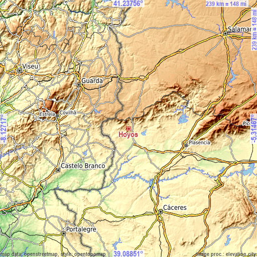
| \ | Map #1 | Topo.Map |
| Scale [m] | 354..1050 m | × |
| Scale [ft] | 1161..3445 ft | × |
| Average | 592.4 m = 1944 ft | × |
| Width | 7.47 km = 4.6 mi | 239 km = 148.5 mi |
| Height | 7.47 km = 4.6 mi | 238.9 km = 148.4 mi |
| ↑Max Latitude | 40.205111° | 41.23756° |
| Latitude at center | 40.17154° | 40.17154° |
| ↓Min Latitude | 40.137952° | 39.08851° |
| ← Min Longitude | -6.764865° | -8.12717° |
| Longitude center | -6.72092° | -6.72092° |
| →Max Longitude | -6.676975° | -5.31467° |
Nearby cities:
Cities around Hoyos sort by population:
• Moraleja elevation 262 m
12.7 km,  155°
155°
• Valverde del Fresno 479 m
14.5 km,  292°
292°
• Cilleros 438 m
8.8 km,  224°
224°
• Gata 642 m
12.8 km,  55°
55°
• Eljas 606 m
11.8 km,  295°
295°
• Perales del Puerto 429 m
3.7 km,  117°
117°
• San Martín de Trevejo 619 m
7.8 km,  305°
305°
• Acebo 506 m
3.3 km,  5°
5°
• Villamiel 758 m
5.6 km, 287°
• Torre de Don Miguel 558 m
13.5 km, 64°
• Villasbuenas de Gata 423 m
8.1 km,  84°
84°
• Santibáñez el Alto 648 m
14.8 km, 84°
Multilingual:
 En español:
Hoyos elevación 519 m.
 En France:
Hoyos élévation 519 m.


Sources and notes:
- [note 1] Map square and city borders are not equal. Map elevation data is calculated only from area inside that square.
- [src 1] Elevation data from geonames database provided with same terms of usage.
- [src 2] The elevation map of Hoyos is generated using elevation data from NASA's 3 arcsec (90m) resolution SRTM data.
- [src 3] Base (background) map © OpenStreetMap contributors tiles are generated by Geofabrik and OpenTopoMap.
Copyright & License:
This Hoyos Elevation Map is licensed under CC BY-SA. You may reuse any part from this page, if you give a proper credit by linking to this URL:
 More info on terms of use page.