Fuenteguinaldo elevation
Fuenteguinaldo (Castille and León, Provincia de Salamanca), Spain elevation is 853 meters and Fuenteguinaldo elevation in feet is 2799 ft above sea level [src 1]. Fuenteguinaldo is a seat of a third-order administrative division (feature code) with elevation that is 250 meters (820 ft) bigger than average city elevation in Spain.
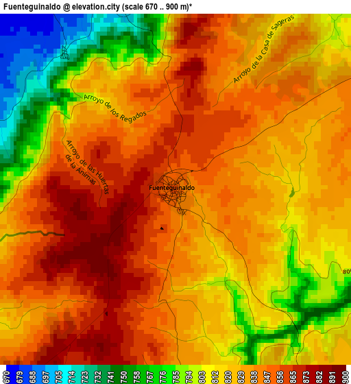
Below is the Elevation map of Fuenteguinaldo, which displays elevation range with different colors. Scale of the first map is from 670 to 900 m (2198 to 2953 ft) with average elevation of 827.3 meters (=2714 ft) [note 1]
These maps also provides idea of topography and contour of this city, they are displayed at different zoom levels. More info about maps, scale and edge coordinates you can find below images.
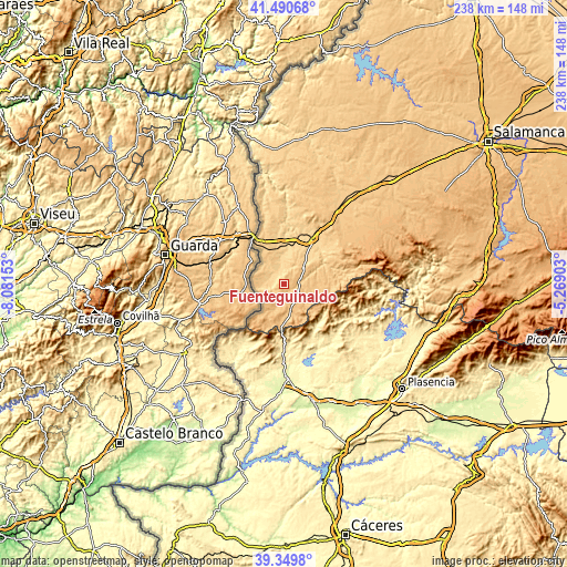
| \ | Map #1 | Topo.Map |
| Scale [m] | 670..900 m | × |
| Scale [ft] | 2198..2953 ft | × |
| Average | 827.3 m = 2714 ft | × |
| Width | 7.44 km = 4.6 mi | 238 km = 147.9 mi |
| Height | 7.44 km = 4.6 mi | 238 km = 147.9 mi |
| ↑Max Latitude | 40.462203° | 41.49068° |
| Latitude at center | 40.42876° | 40.42876° |
| ↓Min Latitude | 40.3953° | 39.3498° |
| ← Min Longitude | -6.719225° | -8.08153° |
| Longitude center | -6.67528° | -6.67528° |
| →Max Longitude | -6.631335° | -5.26903° |
Nearby cities:
Cities around Fuenteguinaldo sort by population:
• Robleda elevation 839 m
7.6 km,  130°
130°
• Peñaparda 866 m
12 km,  177°
177°
• Martiago 812 m
15.9 km,  79°
79°
• Villasrubias 856 m
10.5 km,  163°
163°
• Ituero de Azaba 667 m
6.4 km,  346°
346°
• Espeja 699 m
15.6 km, 347°
• Puebla de Azaba 672 m
6.3 km,  288°
288°
• Campillo de Azaba 656 m
9 km, 353°
• Casillas de Flores 860 m
8.7 km,  232°
232°
• Herguijuela de Ciudad Rodrigo 793 m
13.5 km, 75°
• Carpio de Azaba 682 m
18.8 km,  7°
7°
• Pastores 767 m
16.9 km,  55°
55°
Multilingual:
 En español:
Fuenteguinaldo elevación 853 m.
 En France:
Fuenteguinaldo élévation 853 m.
 Auf Deutsch:
Fuenteguinaldo höhe über dem Meeresspiegel ist 853 m.

Sources and notes:
- [note 1] Map square and city borders are not equal. Map elevation data is calculated only from area inside that square.
- [src 1] Elevation data from geonames database provided with same terms of usage.
- [src 2] The elevation map of Fuenteguinaldo is generated using elevation data from NASA's 3 arcsec (90m) resolution SRTM data.
- [src 3] Base (background) map © OpenStreetMap contributors tiles are generated by Geofabrik and OpenTopoMap.
Copyright & License:
This Fuenteguinaldo Elevation Map is licensed under CC BY-SA. You may reuse any part from this page, if you give a proper credit by linking to this URL:
 More info on terms of use page.