Noviercas elevation
Noviercas (Castille and León, Provincia de Soria), Spain elevation is 1096 meters and Noviercas elevation in feet is 3596 ft above sea level [src 1]. Noviercas is a seat of a third-order administrative division (feature code) with elevation that is 493 meters (1617 ft) bigger than average city elevation in Spain.
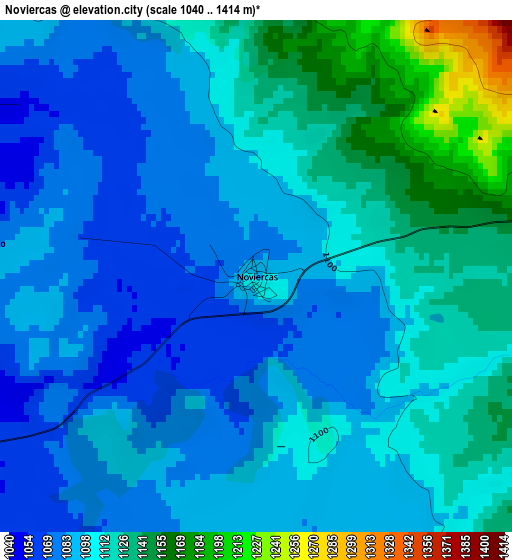
Below is the Elevation map of Noviercas, which displays elevation range with different colors. Scale of the first map is from 1040 to 1414 m (3412 to 4639 ft) with average elevation of 1103.4 meters (=3620 ft) [note 1]
These maps also provides idea of topography and contour of this city, they are displayed at different zoom levels. More info about maps, scale and edge coordinates you can find below images.
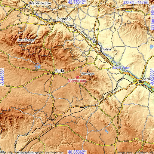
| \ | Map #1 | Topo.Map |
| Scale [m] | 1040..1414 m | × |
| Scale [ft] | 3412..4639 ft | × |
| Average | 1103.4 m = 3620 ft | × |
| Width | 7.3 km = 4.5 mi | 233.4 km = 145 mi |
| Height | 7.3 km = 4.5 mi | 233.4 km = 145 mi |
| ↑Max Latitude | 41.744737° | 42.75312° |
| Latitude at center | 41.71194° | 41.71194° |
| ↓Min Latitude | 41.679126° | 40.65362° |
| ← Min Longitude | -2.078275° | -3.44058° |
| Longitude center | -2.03433° | -2.03433° |
| →Max Longitude | -1.990385° | -0.62808° |
Nearby cities:
Cities around Noviercas sort by population:
• Olvega elevation 1040 m
8.6 km,  29°
29°
• Borobia 1137 m
12.6 km,  114°
114°
• Cueva de Ágreda 1298 m
13.4 km,  64°
64°
• Pozalmuro 1051 m
8.9 km,  321°
321°
• Ciria 1028 m
11.9 km,  151°
151°
• Torrubia de Soria 1044 m
10.2 km,  207°
207°
• Reznos 1048 m
13.5 km,  177°
177°
• Hinojosa del Campo 1036 m
6.2 km,  298°
298°
• Tajahuerce 1057 m
10.1 km,  287°
287°
• Villar del Campo 1036 m
12.8 km,  311°
311°
• Pinilla del Campo 1047 m
4.1 km,  277°
277°
• Portillo de Soria 1025 m
11.2 km,  220°
220°
Multilingual:
 En español:
Noviercas elevación 1096 m.
 En France:
Noviercas élévation 1096 m.
 Auf Deutsch:
Noviercas höhe über dem Meeresspiegel ist 1096 m.

Sources and notes:
- [note 1] Map square and city borders are not equal. Map elevation data is calculated only from area inside that square.
- [src 1] Elevation data from geonames database provided with same terms of usage.
- [src 2] The elevation map of Noviercas is generated using elevation data from NASA's 3 arcsec (90m) resolution SRTM data.
- [src 3] Base (background) map © OpenStreetMap contributors tiles are generated by Geofabrik and OpenTopoMap.
Copyright & License:
This Noviercas Elevation Map is licensed under CC BY-SA. You may reuse any part from this page, if you give a proper credit by linking to this URL:
 More info on terms of use page.