Palencia de Negrilla elevation
Palencia de Negrilla (Castille and León, Provincia de Salamanca), Spain elevation is 825 meters and Palencia de Negrilla elevation in feet is 2707 ft above sea level [src 1]. Palencia de Negrilla is a seat of a third-order administrative division (feature code) with elevation that is 222 meters (728 ft) bigger than average city elevation in Spain.
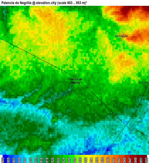
Below is the Elevation map of Palencia de Negrilla, which displays elevation range with different colors. Scale of the first map is from 803 to 853 m (2635 to 2799 ft) with average elevation of 823.5 meters (=2702 ft) [note 1]
These maps also provides idea of topography and contour of this city, they are displayed at different zoom levels. More info about maps, scale and edge coordinates you can find below images.
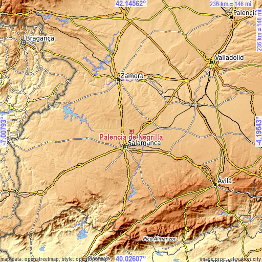
| \ | Map #1 | Topo.Map |
| Scale [m] | 803..853 m | × |
| Scale [ft] | 2635..2799 ft | × |
| Average | 823.5 m = 2702 ft | × |
| Width | 7.36 km = 4.6 mi | 235.7 km = 146.5 mi |
| Height | 7.36 km = 4.6 mi | 235.7 km = 146.5 mi |
| ↑Max Latitude | 41.1275° | 42.14562° |
| Latitude at center | 41.09439° | 41.09439° |
| ↓Min Latitude | 41.061263° | 40.02607° |
| ← Min Longitude | -5.645625° | -7.00793° |
| Longitude center | -5.60168° | -5.60168° |
| →Max Longitude | -5.557735° | -4.19543° |
Nearby cities:
Cities around Palencia de Negrilla sort by population:
• Topas elevation 825 m
7.5 km,  338°
338°
• Monterrubio de Armuña 802 m
8.3 km,  205°
205°
• San Cristóbal de la Cuesta 818 m
7.4 km,  190°
190°
• Gomecello 844 m
8 km,  136°
136°
• Castellanos de Moriscos 836 m
8.4 km,  173°
173°
• Tardáguila 833 m
3.2 km,  45°
45°
• Villaverde de Guareña 831 m
7.3 km,  117°
117°
• Pajares de la Laguna 828 m
7.8 km,  95°
95°
• Pedrosillo el Ralo 815 m
5.7 km,  127°
127°
• Negrilla de Palencia 824 m
0.9 km,  108°
108°
• Arcediano 826 m
3.4 km,  91°
91°
• Valdunciel 806 m
6 km,  260°
260°
Multilingual:
 En español:
Palencia de Negrilla elevación 825 m.
 En France:
Palencia de Negrilla élévation 825 m.
 Auf Deutsch:
Palencia de Negrilla höhe über dem Meeresspiegel ist 825 m.
 На русском:
Palencia de Negrilla высота над уровнем моря 825 м
Sources and notes:
- [note 1] Map square and city borders are not equal. Map elevation data is calculated only from area inside that square.
- [src 1] Elevation data from geonames database provided with same terms of usage.
- [src 2] The elevation map of Palencia de Negrilla is generated using elevation data from NASA's 3 arcsec (90m) resolution SRTM data.
- [src 3] Base (background) map © OpenStreetMap contributors tiles are generated by Geofabrik and OpenTopoMap.
Copyright & License:
This Palencia de Negrilla Elevation Map is licensed under CC BY-SA. You may reuse any part from this page, if you give a proper credit by linking to this URL:
 More info on terms of use page.