Palo elevation
Palo (Aragon, Provincia de Huesca), Spain elevation is 705 meters and Palo elevation in feet is 2313 ft above sea level [src 1]. Palo is a seat of a third-order administrative division (feature code) with elevation that is 102 meters (335 ft) bigger than average city elevation in Spain.
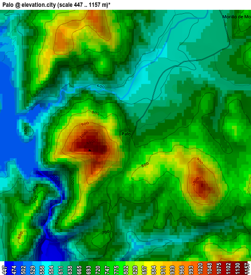
Below is the Elevation map of Palo, which displays elevation range with different colors. Scale of the first map is from 447 to 1157 m (1467 to 3796 ft) with average elevation of 700.8 meters (=2299 ft) [note 1]
These maps also provides idea of topography and contour of this city, they are displayed at different zoom levels. More info about maps, scale and edge coordinates you can find below images.
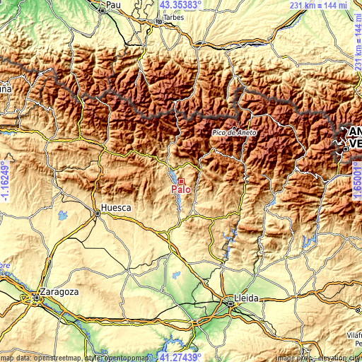
| \ | Map #1 | Topo.Map |
| Scale [m] | 447..1157 m | × |
| Scale [ft] | 1467..3796 ft | × |
| Average | 700.8 m = 2299 ft | × |
| Width | 7.23 km = 4.5 mi | 231.2 km = 143.7 mi |
| Height | 7.23 km = 4.5 mi | 231.2 km = 143.7 mi |
| ↑Max Latitude | 42.355183° | 43.35383° |
| Latitude at center | 42.3227° | 42.3227° |
| ↓Min Latitude | 42.2902° | 41.27439° |
| ← Min Longitude | 0.199815° | -1.16249° |
| Longitude center | 0.24376° | 0.24376° |
| →Max Longitude | 0.287705° | 1.65001° |
Nearby cities:
Cities around Palo sort by population:
• Graus elevation 464 m
16.8 km,  152°
152°
• Aínsa 576 m
13.4 km,  320°
320°
• Boltaña 654 m
19.9 km,  313°
313°
• Capella 523 m
18.8 km,  138°
138°
• Naval 630 m
16.1 km,  208°
208°
• Laspuña 714 m
21.4 km,  339°
339°
• Labuerda 565 m
16.9 km,  328°
328°
• Secastilla 610 m
15.9 km,  172°
172°
• Colungo 621 m
22.2 km,  220°
220°
• Abizanda 627 m
9.7 km,  203°
203°
• Bárcabo 720 m
16.9 km,  238°
238°
• Campo 691 m
15.8 km,  52°
52°
Multilingual:
 En español:
Palo elevación 705 m.
 En France:
Palo élévation 705 m.


Sources and notes:
- [note 1] Map square and city borders are not equal. Map elevation data is calculated only from area inside that square.
- [src 1] Elevation data from geonames database provided with same terms of usage.
- [src 2] The elevation map of Palo is generated using elevation data from NASA's 3 arcsec (90m) resolution SRTM data.
- [src 3] Base (background) map © OpenStreetMap contributors tiles are generated by Geofabrik and OpenTopoMap.
Copyright & License:
This Palo Elevation Map is licensed under CC BY-SA. You may reuse any part from this page, if you give a proper credit by linking to this URL:
 More info on terms of use page.