Paracuellos de Jarama elevation
Paracuellos de Jarama (Madrid, Provincia de Madrid), Spain elevation is 695 meters and Paracuellos de Jarama elevation in feet is 2280 ft above sea level [src 1]. Paracuellos de Jarama is a seat of a third-order administrative division (feature code) with elevation that is 92 meters (302 ft) bigger than average city elevation in Spain.
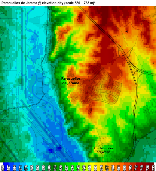
Below is the Elevation map of Paracuellos de Jarama, which displays elevation range with different colors. Scale of the first map is from 550 to 733 m (1804 to 2405 ft) with average elevation of 631.6 meters (=2072 ft) [note 1]
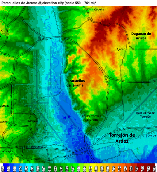
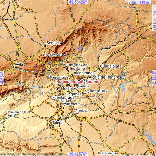
These maps also provides idea of topography and contour of this city, they are displayed at different zoom levels. More info about maps, scale and edge coordinates you can find below images.
| \ | Map #1 | Map #2 | Topo.Map |
| Scale [m] | 550..733 m | 550..761 m | × |
| Scale [ft] | 1804..2405 ft | 1804..2497 ft | × |
| Average | 631.6 m = 2072 ft | 629.6 m = 2066 ft | × |
| Width | 7.43 km = 4.6 mi | 14.86 km = 9.2 mi | 237.8 km = 147.8 mi |
| Height | 7.43 km = 4.6 mi | 14.86 km = 9.2 mi | 237.8 km = 147.8 mi |
| ↑Max Latitude | 40.536936° | 40.570326° | 41.56426° |
| Latitude at center | 40.50353° | 40.50353° | 40.50353° |
| ↓Min Latitude | 40.470107° | 40.436668° | 39.42576° |
| ← Min Longitude | -3.571695° | -3.615641° | -4.934° |
| Longitude center | -3.52775° | -3.52775° | -3.52775° |
| →Max Longitude | -3.483805° | -3.439859° | -2.1215° |
Nearby cities:
Cities around Paracuellos de Jarama sort by population:
• Hortaleza elevation 705 m
10.1 km,  251°
251°
• San Blas-Canillejas 663 m
10.3 km,  225°
225°
• Torrejón de Ardoz 588 m
7.3 km,  137°
137°
• Alcobendas 696 m
10.8 km,  296°
296°
• Coslada 619 m
9.3 km,  197°
197°
• San Sebastián de los Reyes 685 m
10.2 km, 304°
• Barajas de Madrid 625 m
5.4 km, 231°
• San Fernando de Henares 588 m
8.9 km,  182°
182°
• Algete 721 m
10.7 km,  13°
13°
• Daganzo de Arriba 662 m
7.6 km,  54°
54°
• Cobeña 682 m
7.4 km,  18°
18°
• Ajalvir 666 m
5.2 km, 52°
Multilingual:
 En español:
Paracuellos de Jarama elevación 695 m.
 En France:
Paracuellos de Jarama élévation 695 m.
 Auf Deutsch:
Paracuellos de Jarama höhe über dem Meeresspiegel ist 695 m.
 На русском:
Paracuellos de Jarama высота над уровнем моря 695 м
Sources and notes:
- [note 1] Map square and city borders are not equal. Map elevation data is calculated only from area inside that square.
- [src 1] Elevation data from geonames database provided with same terms of usage.
- [src 2] The elevation map of Paracuellos de Jarama is generated using elevation data from NASA's 3 arcsec (90m) resolution SRTM data.
- [src 3] Base (background) map © OpenStreetMap contributors tiles are generated by Geofabrik and OpenTopoMap.
Copyright & License:
This Paracuellos de Jarama Elevation Map is licensed under CC BY-SA. You may reuse any part from this page, if you give a proper credit by linking to this URL:
 More info on terms of use page.