Torrejón de Ardoz elevation
Torrejón de Ardoz (Madrid, Provincia de Madrid), Spain elevation is 588 meters and Torrejón de Ardoz elevation in feet is 1929 ft above sea level [src 1]. Torrejón de Ardoz is a seat of a third-order administrative division (feature code) with elevation that is 15 meters (49 ft) smaller than average city elevation in Spain.
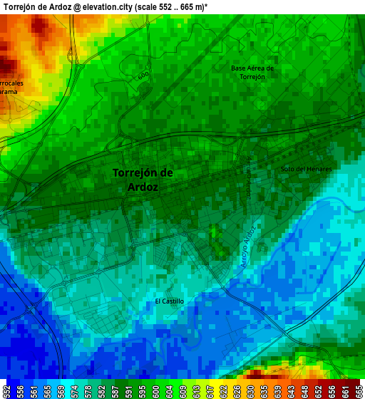
Below is the Elevation map of Torrejón de Ardoz, which displays elevation range with different colors. Scale of the first map is from 552 to 665 m (1811 to 2182 ft) with average elevation of 586.9 meters (=1926 ft) [note 1]
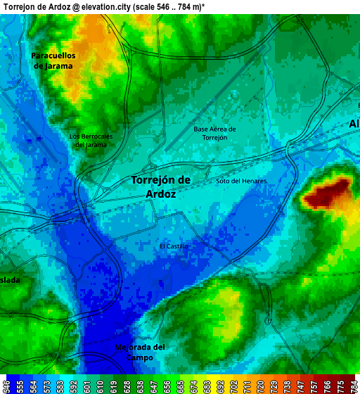
These maps also provides idea of topography and contour of this city, they are displayed at different zoom levels. More info about maps, scale and edge coordinates you can find below images.
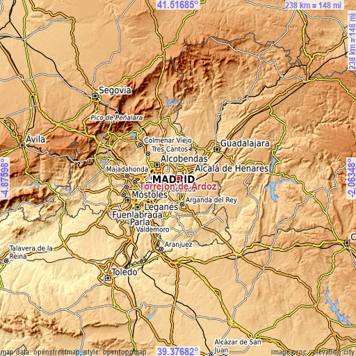
| \ | Map #1 | Map #2 | Topo.Map |
| Scale [m] | 552..665 m | 546..784 m | × |
| Scale [ft] | 1811..2182 ft | 1791..2572 ft | × |
| Average | 586.9 m = 1926 ft | 608 m = 1995 ft | × |
| Width | 7.44 km = 4.6 mi | 14.87 km = 9.2 mi | 237.9 km = 147.8 mi |
| Height | 7.44 km = 4.6 mi | 14.87 km = 9.2 mi | 237.9 km = 147.8 mi |
| ↑Max Latitude | 40.48878° | 40.522194° | 41.51685° |
| Latitude at center | 40.45535° | 40.45535° | 40.45535° |
| ↓Min Latitude | 40.421903° | 40.38844° | 39.37682° |
| ← Min Longitude | -3.513675° | -3.557621° | -4.87598° |
| Longitude center | -3.46973° | -3.46973° | -3.46973° |
| →Max Longitude | -3.425785° | -3.381839° | -2.06348° |
Nearby cities:
Cities around Torrejón de Ardoz sort by population:
• Alcalá de Henares elevation 597 m
9.7 km,  72°
72°
• San Blas-Canillejas 663 m
12.5 km,  261°
261°
• Coslada 619 m
8.5 km,  245°
245°
• Barajas de Madrid 625 m
9.4 km,  282°
282°
• San Fernando de Henares 588 m
6.4 km,  236°
236°
• Mejorada del Campo 580 m
7 km,  188°
188°
• Paracuellos de Jarama 695 m
7.3 km,  317°
317°
• Velilla de San Antonio 554 m
10.1 km, 187°
• Daganzo de Arriba 662 m
9.8 km,  7°
7°
• Torres de la Alameda 672 m
11.1 km,  121°
121°
• Loeches 646 m
9.3 km,  149°
149°
• Ajalvir 666 m
8.6 km,  355°
355°
Multilingual:
 En español:
Torrejón de Ardoz elevación 588 m.
 En France:
Torrejón de Ardoz élévation 588 m.
 Auf Deutsch:
Torrejón de Ardoz höhe über dem Meeresspiegel ist 588 m.

Sources and notes:
- [note 1] Map square and city borders are not equal. Map elevation data is calculated only from area inside that square.
- [src 1] Elevation data from geonames database provided with same terms of usage.
- [src 2] The elevation map of Torrejón de Ardoz is generated using elevation data from NASA's 3 arcsec (90m) resolution SRTM data.
- [src 3] Base (background) map © OpenStreetMap contributors tiles are generated by Geofabrik and OpenTopoMap.
Copyright & License:
This Torrejón de Ardoz Elevation Map is licensed under CC BY-SA. You may reuse any part from this page, if you give a proper credit by linking to this URL:
 More info on terms of use page.