Parrillas elevation
Parrillas (Castille-La Mancha, Province of Toledo), Spain elevation is 401 meters and Parrillas elevation in feet is 1316 ft above sea level [src 1]. Parrillas is a seat of a third-order administrative division (feature code) with elevation that is 202 meters (663 ft) smaller than average city elevation in Spain.
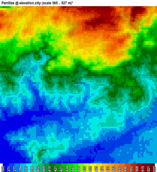
Below is the Elevation map of Parrillas, which displays elevation range with different colors. Scale of the first map is from 365 to 527 m (1198 to 1729 ft) with average elevation of 418.6 meters (=1373 ft) [note 1]
These maps also provides idea of topography and contour of this city, they are displayed at different zoom levels. More info about maps, scale and edge coordinates you can find below images.
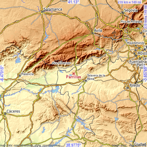
| \ | Map #1 | Topo.Map |
| Scale [m] | 365..527 m | × |
| Scale [ft] | 1198..1729 ft | × |
| Average | 418.6 m = 1373 ft | × |
| Width | 7.48 km = 4.6 mi | 239.3 km = 148.7 mi |
| Height | 7.48 km = 4.6 mi | 239.3 km = 148.7 mi |
| ↑Max Latitude | 40.095875° | 41.13° |
| Latitude at center | 40.06225° | 40.06225° |
| ↓Min Latitude | 40.028608° | 38.9775° |
| ← Min Longitude | -5.107845° | -6.47015° |
| Longitude center | -5.0639° | -5.0639° |
| →Max Longitude | -5.019955° | -3.65765° |
Nearby cities:
Cities around Parrillas sort by population:
• Arenas de San Pedro elevation 531 m
16.6 km,  353°
353°
• Candeleda 431 m
18.2 km,  304°
304°
• Oropesa 417 m
18.6 km,  210°
210°
• Velada 434 m
12.1 km,  141°
141°
• Navalcán 405 m
1.7 km,  286°
286°
• Mejorada 551 m
16.3 km,  110°
110°
• Segurilla 566 m
17.5 km,  104°
104°
• Guisando 788 m
18.9 km,  340°
340°
• Poyales del Hoyo 552 m
15 km,  324°
324°
• Montesclaros 559 m
11.7 km,  65°
65°
• Alcañizo 377 m
18 km,  191°
191°
• Torralba de Oropesa 371 m
16.2 km, 208°
Multilingual:
 En español:
Parrillas elevación 401 m.
 En France:
Parrillas élévation 401 m.
 Auf Deutsch:
Parrillas höhe über dem Meeresspiegel ist 401 m.

Sources and notes:
- [note 1] Map square and city borders are not equal. Map elevation data is calculated only from area inside that square.
- [src 1] Elevation data from geonames database provided with same terms of usage.
- [src 2] The elevation map of Parrillas is generated using elevation data from NASA's 3 arcsec (90m) resolution SRTM data.
- [src 3] Base (background) map © OpenStreetMap contributors tiles are generated by Geofabrik and OpenTopoMap.
Copyright & License:
This Parrillas Elevation Map is licensed under CC BY-SA. You may reuse any part from this page, if you give a proper credit by linking to this URL:
 More info on terms of use page.