Oropesa elevation
Oropesa (Castille-La Mancha, Province of Toledo), Spain elevation is 417 meters and Oropesa elevation in feet is 1368 ft above sea level [src 1]. Oropesa is a seat of a third-order administrative division (feature code) with elevation that is 186 meters (610 ft) smaller than average city elevation in Spain.
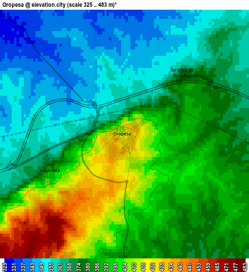
Below is the Elevation map of Oropesa, which displays elevation range with different colors. Scale of the first map is from 325 to 483 m (1066 to 1585 ft) with average elevation of 378.9 meters (=1243 ft) [note 1]
These maps also provides idea of topography and contour of this city, they are displayed at different zoom levels. More info about maps, scale and edge coordinates you can find below images.
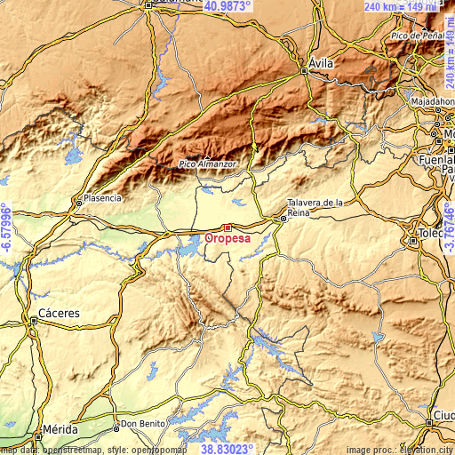
| \ | Map #1 | Topo.Map |
| Scale [m] | 325..483 m | × |
| Scale [ft] | 1066..1585 ft | × |
| Average | 378.9 m = 1243 ft | × |
| Width | 7.5 km = 4.7 mi | 239.8 km = 149 mi |
| Height | 7.5 km = 4.7 mi | 239.8 km = 149 mi |
| ↑Max Latitude | 39.950957° | 40.9873° |
| Latitude at center | 39.91726° | 39.91726° |
| ↓Min Latitude | 39.883547° | 38.83023° |
| ← Min Longitude | -5.217655° | -6.57996° |
| Longitude center | -5.17371° | -5.17371° |
| →Max Longitude | -5.129765° | -3.76746° |
Nearby cities:
Cities around Oropesa sort by population:
• Calera y Chozas elevation 389 m
16.8 km,  103°
103°
• Velada 434 m
18.1 km,  68°
68°
• Lagartera 396 m
2.7 km,  241°
241°
• El Puente del Arzobispo 340 m
12.8 km,  179°
179°
• Torrico 441 m
10.8 km,  204°
204°
• Alcolea de Tajo 354 m
12.2 km,  169°
169°
• Valdeverdeja 475 m
14.8 km, 204°
• Herreruela de Oropesa 380 m
6.7 km, 242°
• Azután 337 m
15.2 km,  164°
164°
• Alcañizo 377 m
6 km,  105°
105°
• Caleruela 373 m
8.5 km, 236°
• Torralba de Oropesa 371 m
2.5 km,  42°
42°
Multilingual:
 En español:
Oropesa elevación 417 m.
 En France:
Oropesa élévation 417 m.


Sources and notes:
- [note 1] Map square and city borders are not equal. Map elevation data is calculated only from area inside that square.
- [src 1] Elevation data from geonames database provided with same terms of usage.
- [src 2] The elevation map of Oropesa is generated using elevation data from NASA's 3 arcsec (90m) resolution SRTM data.
- [src 3] Base (background) map © OpenStreetMap contributors tiles are generated by Geofabrik and OpenTopoMap.
Copyright & License:
This Oropesa Elevation Map is licensed under CC BY-SA. You may reuse any part from this page, if you give a proper credit by linking to this URL:
 More info on terms of use page.