Velada elevation
Velada (Castille-La Mancha, Province of Toledo), Spain elevation is 434 meters and Velada elevation in feet is 1424 ft above sea level [src 1]. Velada is a seat of a third-order administrative division (feature code) with elevation that is 169 meters (554 ft) smaller than average city elevation in Spain.
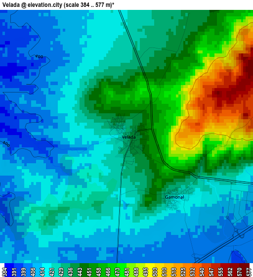
Below is the Elevation map of Velada, which displays elevation range with different colors. Scale of the first map is from 384 to 577 m (1260 to 1893 ft) with average elevation of 433.8 meters (=1423 ft) [note 1]
These maps also provides idea of topography and contour of this city, they are displayed at different zoom levels. More info about maps, scale and edge coordinates you can find below images.
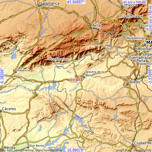
| \ | Map #1 | Topo.Map |
| Scale [m] | 384..577 m | × |
| Scale [ft] | 1260..1893 ft | × |
| Average | 433.8 m = 1423 ft | × |
| Width | 7.49 km = 4.7 mi | 239.6 km = 148.9 mi |
| Height | 7.49 km = 4.7 mi | 239.6 km = 148.9 mi |
| ↑Max Latitude | 40.010537° | 41.04597° |
| Latitude at center | 39.97687° | 39.97687° |
| ↓Min Latitude | 39.943186° | 38.89078° |
| ← Min Longitude | -5.020355° | -6.38266° |
| Longitude center | -4.97641° | -4.97641° |
| →Max Longitude | -4.932465° | -3.57016° |
Nearby cities:
Cities around Velada sort by population:
• Talavera de la Reina elevation 380 m
12.5 km,  96°
96°
• Calera y Chozas 389 m
10.5 km,  182°
182°
• Oropesa 417 m
18.1 km,  248°
248°
• Navalcán 405 m
13.5 km,  317°
317°
• Mejorada 551 m
8.6 km,  64°
64°
• Segurilla 566 m
10.9 km, 61°
• Montesclaros 559 m
14.8 km,  12°
12°
• Parrillas 401 m
12.1 km, 321°
• Cervera de los Montes 535 m
16.4 km, 59°
• Alcañizo 377 m
13.7 km,  233°
233°
• Torralba de Oropesa 371 m
15.9 km, 252°
• Sotillo de las Palomas 563 m
19 km,  42°
42°
Multilingual:
 En español:
Velada elevación 434 m.
 En France:
Velada élévation 434 m.


Sources and notes:
- [note 1] Map square and city borders are not equal. Map elevation data is calculated only from area inside that square.
- [src 1] Elevation data from geonames database provided with same terms of usage.
- [src 2] The elevation map of Velada is generated using elevation data from NASA's 3 arcsec (90m) resolution SRTM data.
- [src 3] Base (background) map © OpenStreetMap contributors tiles are generated by Geofabrik and OpenTopoMap.
Copyright & License:
This Velada Elevation Map is licensed under CC BY-SA. You may reuse any part from this page, if you give a proper credit by linking to this URL:
 More info on terms of use page.