Peñalba elevation
Peñalba (Aragon, Provincia de Huesca), Spain elevation is 246 meters and Peñalba elevation in feet is 807 ft above sea level [src 1]. Peñalba is a seat of a third-order administrative division (feature code) with elevation that is 357 meters (1171 ft) smaller than average city elevation in Spain.
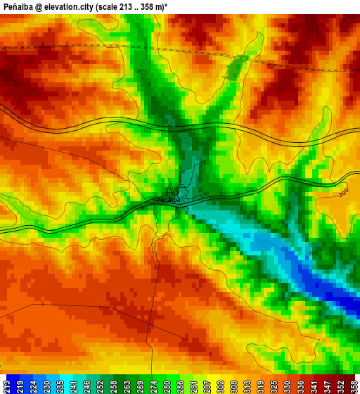
Below is the Elevation map of Peñalba, which displays elevation range with different colors. Scale of the first map is from 213 to 358 m (699 to 1175 ft) with average elevation of 304.8 meters (=1000 ft) [note 1]
These maps also provides idea of topography and contour of this city, they are displayed at different zoom levels. More info about maps, scale and edge coordinates you can find below images.
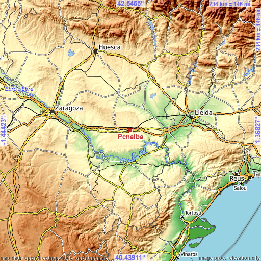
| \ | Map #1 | Topo.Map |
| Scale [m] | 213..358 m | × |
| Scale [ft] | 699..1175 ft | × |
| Average | 304.8 m = 1000 ft | × |
| Width | 7.32 km = 4.5 mi | 234.2 km = 145.5 mi |
| Height | 7.32 km = 4.5 mi | 234.2 km = 145.5 mi |
| ↑Max Latitude | 41.533774° | 42.5455° |
| Latitude at center | 41.50087° | 41.50087° |
| ↓Min Latitude | 41.467949° | 40.43911° |
| ← Min Longitude | -0.081925° | -1.44423° |
| Longitude center | -0.03798° | -0.03798° |
| →Max Longitude | 0.005965° | 1.36827° |
Nearby cities:
Cities around Peñalba sort by population:
• Zaidín elevation 162 m
27.6 km,  65°
65°
• Alcolea de Cinca 192 m
27.5 km,  27°
27°
• Ballobar 152 m
23.3 km,  55°
55°
• Bujaraloz 334 m
9.6 km,  268°
268°
• Castejón de Monegros 477 m
21.3 km,  307°
307°
• Ontiñena 215 m
22.2 km, 28°
• Villanueva de Sigena 235 m
24 km,  5°
5°
• Candasnos 286 m
8.5 km,  89°
89°
• Chiprana 171 m
27.5 km,  195°
195°
• Albalatillo 261 m
27.7 km,  340°
340°
• Chalamera 180 m
24.8 km,  42°
42°
• Valfarta 369 m
10.1 km, 308°
Multilingual:
 En español:
Peñalba elevación 246 m.
 En France:
Peñalba élévation 246 m.


Sources and notes:
- [note 1] Map square and city borders are not equal. Map elevation data is calculated only from area inside that square.
- [src 1] Elevation data from geonames database provided with same terms of usage.
- [src 2] The elevation map of Peñalba is generated using elevation data from NASA's 3 arcsec (90m) resolution SRTM data.
- [src 3] Base (background) map © OpenStreetMap contributors tiles are generated by Geofabrik and OpenTopoMap.
Copyright & License:
This Peñalba Elevation Map is licensed under CC BY-SA. You may reuse any part from this page, if you give a proper credit by linking to this URL:
 More info on terms of use page.