Chiprana elevation
Chiprana (Aragon, Provincia de Zaragoza), Spain elevation is 171 meters and Chiprana elevation in feet is 561 ft above sea level [src 1]. Chiprana is a seat of a third-order administrative division (feature code) with elevation that is 432 meters (1417 ft) smaller than average city elevation in Spain.
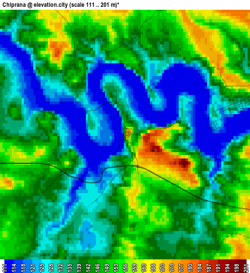
Below is the Elevation map of Chiprana, which displays elevation range with different colors. Scale of the first map is from 111 to 201 m (364 to 659 ft) with average elevation of 139.7 meters (=458 ft) [note 1]
These maps also provides idea of topography and contour of this city, they are displayed at different zoom levels. More info about maps, scale and edge coordinates you can find below images.
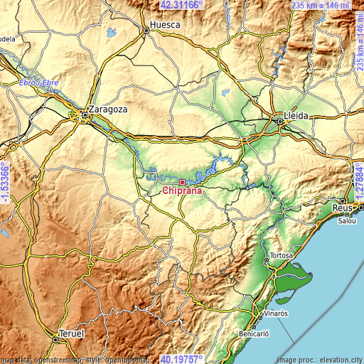
| \ | Map #1 | Topo.Map |
| Scale [m] | 111..201 m | × |
| Scale [ft] | 364..659 ft | × |
| Average | 139.7 m = 458 ft | × |
| Width | 7.35 km = 4.6 mi | 235.1 km = 146.1 mi |
| Height | 7.35 km = 4.6 mi | 235.1 km = 146.1 mi |
| ↑Max Latitude | 41.296195° | 42.31166° |
| Latitude at center | 41.26317° | 41.26317° |
| ↓Min Latitude | 41.230128° | 40.19757° |
| ← Min Longitude | -0.171355° | -1.53366° |
| Longitude center | -0.12741° | -0.12741° |
| →Max Longitude | -0.083465° | 1.27884° |
Nearby cities:
Cities around Chiprana sort by population:
• Alcañiz elevation 346 m
23.7 km,  181°
181°
• Caspe 171 m
8 km,  113°
113°
• Sástago 153 m
19.8 km,  289°
289°
• Fabara 255 m
26.6 km, 111°
• Escatrón 158 m
16.7 km,  280°
280°
• Bujaraloz 334 m
26.2 km,  355°
355°
• Samper de Calanda 258 m
23.4 km,  249°
249°
• Alborge 154 m
20.7 km, 292°
• Cinco Olivas 159 m
22.1 km, 292°
• Castelnou 194 m
20.2 km,  259°
259°
• Alforque 165 m
22.8 km, 288°
• Jatiel 215 m
21.8 km, 257°
Multilingual:
 En español:
Chiprana elevación 171 m.
 En France:
Chiprana élévation 171 m.
 Auf Deutsch:
Chiprana höhe über dem Meeresspiegel ist 171 m.

Sources and notes:
- [note 1] Map square and city borders are not equal. Map elevation data is calculated only from area inside that square.
- [src 1] Elevation data from geonames database provided with same terms of usage.
- [src 2] The elevation map of Chiprana is generated using elevation data from NASA's 3 arcsec (90m) resolution SRTM data.
- [src 3] Base (background) map © OpenStreetMap contributors tiles are generated by Geofabrik and OpenTopoMap.
Copyright & License:
This Chiprana Elevation Map is licensed under CC BY-SA. You may reuse any part from this page, if you give a proper credit by linking to this URL:
 More info on terms of use page.