Sástago elevation
Sástago (Aragon, Provincia de Zaragoza), Spain elevation is 153 meters and Sástago elevation in feet is 502 ft above sea level [src 1]. Sástago is a seat of a third-order administrative division (feature code) with elevation that is 450 meters (1476 ft) smaller than average city elevation in Spain.
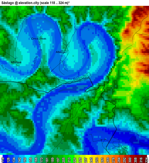
Below is the Elevation map of Sástago, which displays elevation range with different colors. Scale of the first map is from 118 to 324 m (387 to 1063 ft) with average elevation of 171.8 meters (=564 ft) [note 1]
These maps also provides idea of topography and contour of this city, they are displayed at different zoom levels. More info about maps, scale and edge coordinates you can find below images.
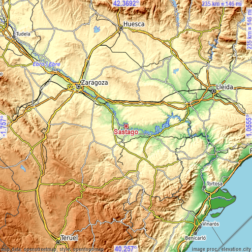
| \ | Map #1 | Topo.Map |
| Scale [m] | 118..324 m | × |
| Scale [ft] | 387..1063 ft | × |
| Average | 171.8 m = 564 ft | × |
| Width | 7.34 km = 4.6 mi | 234.9 km = 146 mi |
| Height | 7.34 km = 4.6 mi | 234.8 km = 145.9 mi |
| ↑Max Latitude | 41.354655° | 42.3692° |
| Latitude at center | 41.32166° | 41.32166° |
| ↓Min Latitude | 41.288648° | 40.257° |
| ← Min Longitude | -0.394695° | -1.757° |
| Longitude center | -0.35075° | -0.35075° |
| →Max Longitude | -0.306805° | 1.0555° |
Nearby cities:
Cities around Sástago sort by population:
• Quinto elevation 158 m
16.6 km,  313°
313°
• Híjar 288 m
18.4 km,  207°
207°
• Gelsa 153 m
13.3 km,  315°
315°
• Escatrón 158 m
4.1 km,  145°
145°
• Samper de Calanda 258 m
15.1 km,  192°
192°
• Velilla de Ebro 176 m
9.1 km, 309°
• Alborge 154 m
1.4 km,  339°
339°
• Cinco Olivas 159 m
2.6 km, 319°
• Castelnou 194 m
10.4 km, 186°
• Alforque 165 m
3 km,  286°
286°
• Jatiel 215 m
11.6 km, 192°
• Almochuel 278 m
17.3 km,  254°
254°
Multilingual:
 En español:
Sástago elevación 153 m.
 En France:
Sástago élévation 153 m.


Sources and notes:
- [note 1] Map square and city borders are not equal. Map elevation data is calculated only from area inside that square.
- [src 1] Elevation data from geonames database provided with same terms of usage.
- [src 2] The elevation map of Sástago is generated using elevation data from NASA's 3 arcsec (90m) resolution SRTM data.
- [src 3] Base (background) map © OpenStreetMap contributors tiles are generated by Geofabrik and OpenTopoMap.
Copyright & License:
This Sástago Elevation Map is licensed under CC BY-SA. You may reuse any part from this page, if you give a proper credit by linking to this URL:
 More info on terms of use page.