Retiendas elevation
Retiendas (Castille-La Mancha, Provincia de Guadalajara), Spain elevation is 917 meters and Retiendas elevation in feet is 3009 ft above sea level [src 1]. Retiendas is a seat of a third-order administrative division (feature code) with elevation that is 314 meters (1030 ft) bigger than average city elevation in Spain.
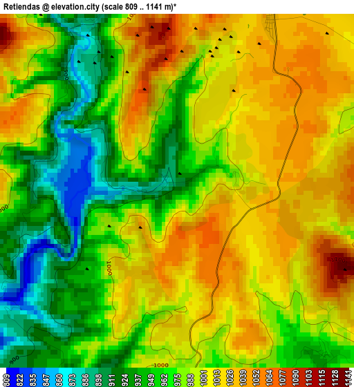
Below is the Elevation map of Retiendas, which displays elevation range with different colors. Scale of the first map is from 809 to 1141 m (2654 to 3743 ft) with average elevation of 987 meters (=3238 ft) [note 1]
These maps also provides idea of topography and contour of this city, they are displayed at different zoom levels. More info about maps, scale and edge coordinates you can find below images.
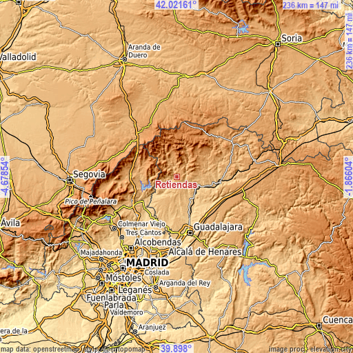
| \ | Map #1 | Topo.Map |
| Scale [m] | 809..1141 m | × |
| Scale [ft] | 2654..3743 ft | × |
| Average | 987 m = 3238 ft | × |
| Width | 7.38 km = 4.6 mi | 236.1 km = 146.7 mi |
| Height | 7.38 km = 4.6 mi | 236.1 km = 146.7 mi |
| ↑Max Latitude | 41.001524° | 42.02161° |
| Latitude at center | 40.96835° | 40.96835° |
| ↓Min Latitude | 40.93516° | 39.898° |
| ← Min Longitude | -3.316235° | -4.67854° |
| Longitude center | -3.27229° | -3.27229° |
| →Max Longitude | -3.228345° | -1.86604° |
Nearby cities:
Cities around Retiendas sort by population:
• Cogolludo elevation 880 m
15.5 km,  98°
98°
• Tamajón 1032 m
4 km,  31°
31°
• Campillo de Ranas 1100 m
13.5 km,  344°
344°
• Arbancón 904 m
13.2 km,  91°
91°
• Valdepeñas de la Sierra 844 m
11.7 km,  233°
233°
• Robledillo de Mohernando 874 m
13.5 km,  165°
165°
• Matarrubia 877 m
11.6 km,  187°
187°
• Puebla de Beleña 910 m
10.1 km,  152°
152°
• Montarrón 837 m
14.9 km,  117°
117°
• Tortuero 943 m
7.6 km,  239°
239°
• Monasterio 935 m
14.8 km,  82°
82°
• Valdesotos 827 m
4.7 km,  252°
252°
Multilingual:
 En español:
Retiendas elevación 917 m.
 En France:
Retiendas élévation 917 m.
 Auf Deutsch:
Retiendas höhe über dem Meeresspiegel ist 917 m.

Sources and notes:
- [note 1] Map square and city borders are not equal. Map elevation data is calculated only from area inside that square.
- [src 1] Elevation data from geonames database provided with same terms of usage.
- [src 2] The elevation map of Retiendas is generated using elevation data from NASA's 3 arcsec (90m) resolution SRTM data.
- [src 3] Base (background) map © OpenStreetMap contributors tiles are generated by Geofabrik and OpenTopoMap.
Copyright & License:
This Retiendas Elevation Map is licensed under CC BY-SA. You may reuse any part from this page, if you give a proper credit by linking to this URL:
 More info on terms of use page.