Montarrón elevation
Montarrón (Castille-La Mancha, Provincia de Guadalajara), Spain elevation is 837 meters and Montarrón elevation in feet is 2746 ft above sea level [src 1]. Montarrón is a seat of a third-order administrative division (feature code) with elevation that is 234 meters (768 ft) bigger than average city elevation in Spain.
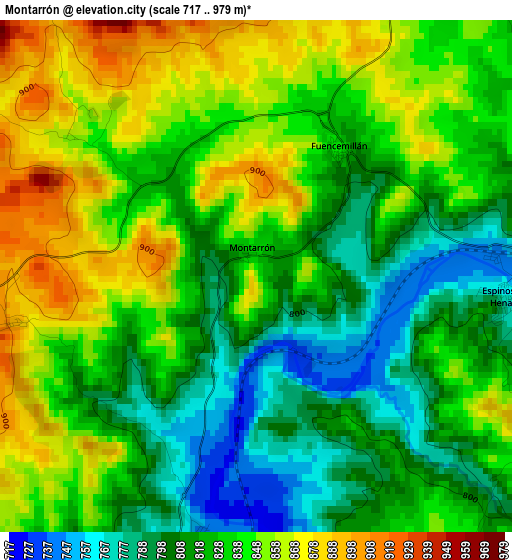
Below is the Elevation map of Montarrón, which displays elevation range with different colors. Scale of the first map is from 717 to 979 m (2352 to 3212 ft) with average elevation of 830.4 meters (=2724 ft) [note 1]
These maps also provides idea of topography and contour of this city, they are displayed at different zoom levels. More info about maps, scale and edge coordinates you can find below images.
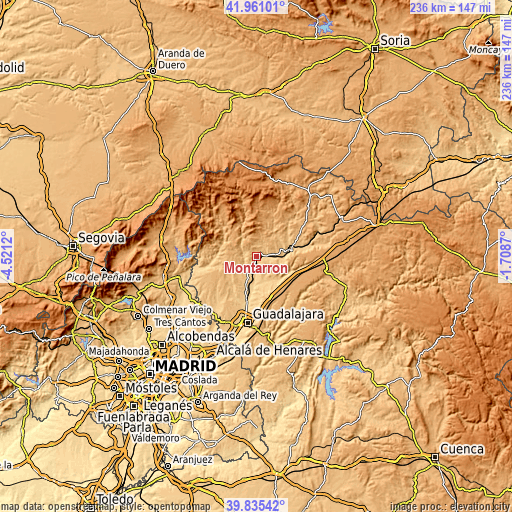
| \ | Map #1 | Topo.Map |
| Scale [m] | 717..979 m | × |
| Scale [ft] | 2352..3212 ft | × |
| Average | 830.4 m = 2724 ft | × |
| Width | 7.39 km = 4.6 mi | 236.3 km = 146.8 mi |
| Height | 7.39 km = 4.6 mi | 236.3 km = 146.8 mi |
| ↑Max Latitude | 40.939954° | 41.96101° |
| Latitude at center | 40.90675° | 40.90675° |
| ↓Min Latitude | 40.873529° | 39.83542° |
| ← Min Longitude | -3.158895° | -4.5212° |
| Longitude center | -3.11495° | -3.11495° |
| →Max Longitude | -3.071005° | -1.7087° |
Nearby cities:
Cities around Montarrón sort by population:
• Humanes elevation 746 m
9.5 km,  199°
199°
• Espinosa de Henares 769 m
3.9 km,  100°
100°
• Cogolludo 880 m
5 km,  25°
25°
• Hita 815 m
11.1 km,  148°
148°
• Arbancón 904 m
6.4 km,  359°
359°
• Robledillo de Mohernando 874 m
11.6 km,  237°
237°
• Alarilla 800 m
6.7 km,  171°
171°
• Fuencemillán 799 m
2.1 km,  42°
42°
• Puebla de Beleña 910 m
8.8 km,  256°
256°
• Taragudo 745 m
10.1 km,  161°
161°
• Monasterio 935 m
8.9 km,  9°
9°
• Copernal 859 m
6.9 km,  132°
132°
Multilingual:
 En español:
Montarrón elevación 837 m.
 En France:
Montarrón élévation 837 m.
 Auf Deutsch:
Montarrón höhe über dem Meeresspiegel ist 837 m.

Sources and notes:
- [note 1] Map square and city borders are not equal. Map elevation data is calculated only from area inside that square.
- [src 1] Elevation data from geonames database provided with same terms of usage.
- [src 2] The elevation map of Montarrón is generated using elevation data from NASA's 3 arcsec (90m) resolution SRTM data.
- [src 3] Base (background) map © OpenStreetMap contributors tiles are generated by Geofabrik and OpenTopoMap.
Copyright & License:
This Montarrón Elevation Map is licensed under CC BY-SA. You may reuse any part from this page, if you give a proper credit by linking to this URL:
 More info on terms of use page.