Tamajón elevation
Tamajón (Castille-La Mancha, Provincia de Guadalajara), Spain elevation is 1032 meters and Tamajón elevation in feet is 3386 ft above sea level [src 1]. Tamajón is a seat of a third-order administrative division (feature code) with elevation that is 429 meters (1407 ft) bigger than average city elevation in Spain.
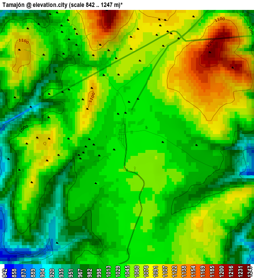
Below is the Elevation map of Tamajón, which displays elevation range with different colors. Scale of the first map is from 842 to 1247 m (2762 to 4091 ft) with average elevation of 1036.2 meters (=3400 ft) [note 1]
These maps also provides idea of topography and contour of this city, they are displayed at different zoom levels. More info about maps, scale and edge coordinates you can find below images.
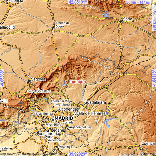
| \ | Map #1 | Topo.Map |
| Scale [m] | 842..1247 m | × |
| Scale [ft] | 2762..4091 ft | × |
| Average | 1036.2 m = 3400 ft | × |
| Width | 7.38 km = 4.6 mi | 236 km = 146.6 mi |
| Height | 7.38 km = 4.6 mi | 236 km = 146.6 mi |
| ↑Max Latitude | 41.032298° | 42.05191° |
| Latitude at center | 40.99914° | 40.99914° |
| ↓Min Latitude | 40.965965° | 39.92929° |
| ← Min Longitude | -3.291375° | -4.65368° |
| Longitude center | -3.24743° | -3.24743° |
| →Max Longitude | -3.203485° | -1.84118° |
Nearby cities:
Cities around Tamajón sort by population:
• Cogolludo elevation 880 m
14.5 km,  113°
113°
• Campillo de Ranas 1100 m
11.2 km,  329°
329°
• Arbancón 904 m
11.8 km, 109°
• Valverde de los Arroyos 1257 m
14.5 km,  4°
4°
• Majaelrayo 1187 m
13.4 km,  339°
339°
• Puebla de Beleña 910 m
12.6 km,  168°
168°
• Semillas 1201 m
12.6 km,  58°
58°
• Retiendas 917 m
4 km,  211°
211°
• Arroyo de las Fraguas 1215 m
15.1 km,  40°
40°
• Tortuero 943 m
11.3 km,  230°
230°
• Monasterio 935 m
12.7 km,  96°
96°
• Valdesotos 827 m
8.2 km, 233°
Multilingual:
 En español:
Tamajón elevación 1032 m.
 En France:
Tamajón élévation 1032 m.
 Auf Deutsch:
Tamajón höhe über dem Meeresspiegel ist 1032 m.

Sources and notes:
- [note 1] Map square and city borders are not equal. Map elevation data is calculated only from area inside that square.
- [src 1] Elevation data from geonames database provided with same terms of usage.
- [src 2] The elevation map of Tamajón is generated using elevation data from NASA's 3 arcsec (90m) resolution SRTM data.
- [src 3] Base (background) map © OpenStreetMap contributors tiles are generated by Geofabrik and OpenTopoMap.
Copyright & License:
This Tamajón Elevation Map is licensed under CC BY-SA. You may reuse any part from this page, if you give a proper credit by linking to this URL:
 More info on terms of use page.