Santa Cruz de Yanguas elevation
Santa Cruz de Yanguas (Castille and León, Provincia de Soria), Spain elevation is 1215 meters and Santa Cruz de Yanguas elevation in feet is 3986 ft above sea level [src 1]. Santa Cruz de Yanguas is a seat of a third-order administrative division (feature code) with elevation that is 612 meters (2008 ft) bigger than average city elevation in Spain.
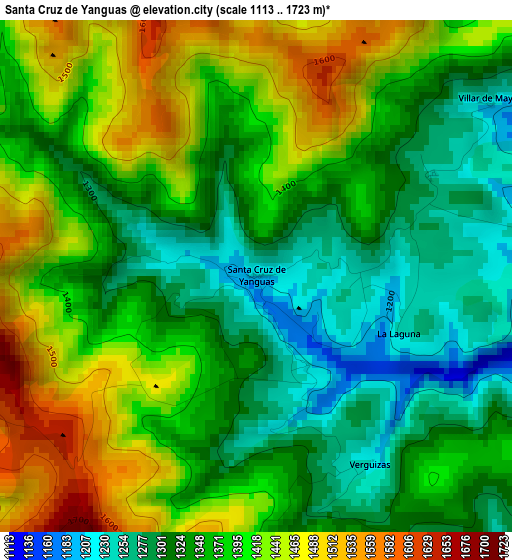
Below is the Elevation map of Santa Cruz de Yanguas, which displays elevation range with different colors. Scale of the first map is from 1113 to 1723 m (3652 to 5653 ft) with average elevation of 1371.1 meters (=4498 ft) [note 1]
These maps also provides idea of topography and contour of this city, they are displayed at different zoom levels. More info about maps, scale and edge coordinates you can find below images.
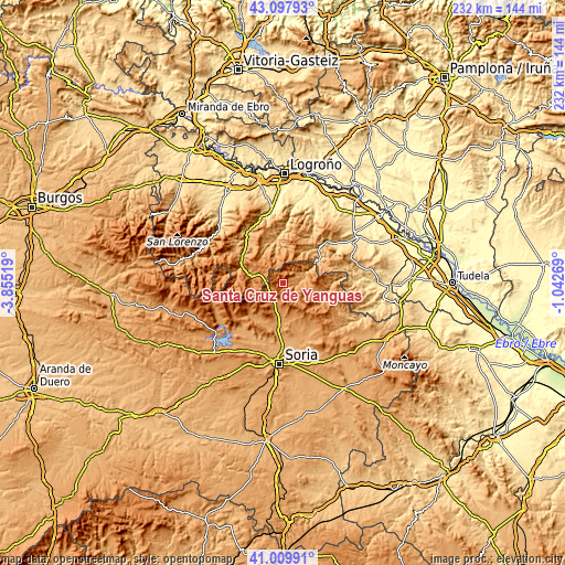
| \ | Map #1 | Topo.Map |
| Scale [m] | 1113..1723 m | × |
| Scale [ft] | 3652..5653 ft | × |
| Average | 1371.1 m = 4498 ft | × |
| Width | 7.26 km = 4.5 mi | 232.2 km = 144.3 mi |
| Height | 7.26 km = 4.5 mi | 232.2 km = 144.3 mi |
| ↑Max Latitude | 42.095117° | 43.09793° |
| Latitude at center | 42.0625° | 42.0625° |
| ↓Min Latitude | 42.029866° | 41.00991° |
| ← Min Longitude | -2.492885° | -3.85519° |
| Longitude center | -2.44894° | -2.44894° |
| →Max Longitude | -2.404995° | -1.04269° |
Nearby cities:
Cities around Santa Cruz de Yanguas sort by population:
• Almarza elevation 1153 m
13 km,  187°
187°
• Villar del Río 1009 m
8.2 km,  79°
79°
• Laguna de Cameros 1036 m
14.7 km,  328°
328°
• Lumbreras 1199 m
15 km,  288°
288°
• Yanguas 989 m
10 km,  64°
64°
• Oncala 1304 m
15.1 km,  132°
132°
• Arévalo de la Sierra 1208 m
13.4 km,  162°
162°
• Ajamil 1046 m
12.1 km,  344°
344°
• Rabanera 974 m
14.5 km,  347°
347°
• Vizmanos 1207 m
5.5 km,  142°
142°
• Cabezón de Cameros 940 m
16.1 km, 338°
• Zarzosa 975 m
16 km,  33°
33°
Multilingual:
 En español:
Santa Cruz de Yanguas elevación 1215 m.
 En France:
Santa Cruz de Yanguas élévation 1215 m.
 Auf Deutsch:
Santa Cruz de Yanguas höhe über dem Meeresspiegel ist 1215 m.
 На русском:
Санта-Крус-де-Янгвас высота над уровнем моря 1215 м
Sources and notes:
- [note 1] Map square and city borders are not equal. Map elevation data is calculated only from area inside that square.
- [src 1] Elevation data from geonames database provided with same terms of usage.
- [src 2] The elevation map of Santa Cruz de Yanguas is generated using elevation data from NASA's 3 arcsec (90m) resolution SRTM data.
- [src 3] Base (background) map © OpenStreetMap contributors tiles are generated by Geofabrik and OpenTopoMap.
Copyright & License:
This Santa Cruz de Yanguas Elevation Map is licensed under CC BY-SA. You may reuse any part from this page, if you give a proper credit by linking to this URL:
 More info on terms of use page.